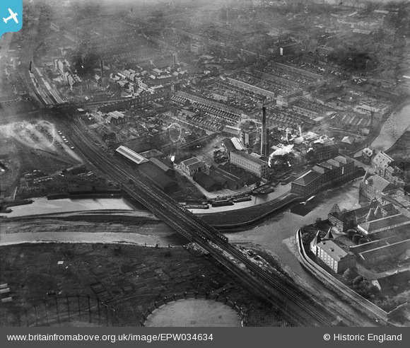
EPW034634 ENGLAND (1930). Kemball, Bishop and Co Crown Chemical Works and environs, Bromley, 1930
© Copyright OpenStreetMap contributors and licensed by the OpenStreetMap Foundation. 2026. Cartography is licensed as CC BY-SA.
Nearby Images (26)
Details
| Title | [EPW034634] Kemball, Bishop and Co Crown Chemical Works and environs, Bromley, 1930 |
| Reference | EPW034634 |
| Date | 16-October-1930 |
| Link | |
| Place name | BROMLEY |
| Parish | |
| District | |
| Country | ENGLAND |
| Easting / Northing | 538233, 182661 |
| Longitude / Latitude | -0.0071443340965499, 51.525440582165 |
| National Grid Reference | TQ382827 |
Pins
Be the first to add a comment to this image!


![[EPW034634] Kemball, Bishop and Co Crown Chemical Works and environs, Bromley, 1930](http://britainfromabove.org.uk/sites/all/libraries/aerofilms-images/public/100x100/EPW/034/EPW034634.jpg)
![[EPW034626] Kemball, Bishop and Co Crown Chemical Works and environs, Bromley, 1930](http://britainfromabove.org.uk/sites/all/libraries/aerofilms-images/public/100x100/EPW/034/EPW034626.jpg)
![[EPW034628] Kemball, Bishop and Co Crown Chemical Works and environs, Bromley, 1930](http://britainfromabove.org.uk/sites/all/libraries/aerofilms-images/public/100x100/EPW/034/EPW034628.jpg)
![[EPW034627] Kemball, Bishop and Co Crown Chemical Works and environs, Bromley, 1930](http://britainfromabove.org.uk/sites/all/libraries/aerofilms-images/public/100x100/EPW/034/EPW034627.jpg)
![[EPW045655] The Art Sales Ltd Works and the Three Mills Distillery, Bromley, 1934. This image has been produced from a damaged negative.](http://britainfromabove.org.uk/sites/all/libraries/aerofilms-images/public/100x100/EPW/045/EPW045655.jpg)
![[EPW051051] The Kemball, Bishop and Co Ltd Crown Chemical Works, Bromley, 1936](http://britainfromabove.org.uk/sites/all/libraries/aerofilms-images/public/100x100/EPW/051/EPW051051.jpg)
![[EPW034632] Kemball, Bishop and Co Crown Chemical Works and environs, Bromley, 1930](http://britainfromabove.org.uk/sites/all/libraries/aerofilms-images/public/100x100/EPW/034/EPW034632.jpg)
![[EPW034631] Kemball, Bishop and Co Crown Chemical Works and environs, Bromley, 1930](http://britainfromabove.org.uk/sites/all/libraries/aerofilms-images/public/100x100/EPW/034/EPW034631.jpg)
![[EPW034625] Kemball, Bishop and Co Crown Chemical Works, Bromley, 1930](http://britainfromabove.org.uk/sites/all/libraries/aerofilms-images/public/100x100/EPW/034/EPW034625.jpg)
![[EAW028115] The Kemball, Bishop and Co Crown Chemical Works and the surrounding area, Bromley, 1950. This image has been produced from a damaged negative.](http://britainfromabove.org.uk/sites/all/libraries/aerofilms-images/public/100x100/EAW/028/EAW028115.jpg)
![[EAW028116] The Kemball, Bishop and Co Crown Chemical Works and the surrounding area, Bromley, 1950. This image has been produced from a damaged negative.](http://britainfromabove.org.uk/sites/all/libraries/aerofilms-images/public/100x100/EAW/028/EAW028116.jpg)
![[EPW034629] Kemball, Bishop and Co Crown Chemical Works and environs, Bromley, 1930](http://britainfromabove.org.uk/sites/all/libraries/aerofilms-images/public/100x100/EPW/034/EPW034629.jpg)
![[EPW045658] The Art Sales Ltd Works, the Three Mills Distillery and the surrounding residential area, Bromley, 1934](http://britainfromabove.org.uk/sites/all/libraries/aerofilms-images/public/100x100/EPW/045/EPW045658.jpg)
![[EPW051050] The Kemball, Bishop and Co Ltd Crown Chemical Works, Bromley, 1936](http://britainfromabove.org.uk/sites/all/libraries/aerofilms-images/public/100x100/EPW/051/EPW051050.jpg)
![[EAW028117] The Kemball, Bishop and Co Crown Chemical Works (site of) and the surrounding area, Bromley, 1950. This image has been produced from a damaged negative.](http://britainfromabove.org.uk/sites/all/libraries/aerofilms-images/public/100x100/EAW/028/EAW028117.jpg)
![[EPW034630] Kemball, Bishop and Co Crown Chemical Works and environs, Bromley, 1930](http://britainfromabove.org.uk/sites/all/libraries/aerofilms-images/public/100x100/EPW/034/EPW034630.jpg)
![[EPW034633] Kemball, Bishop and Co Crown Chemical Works and environs, Bromley, 1930](http://britainfromabove.org.uk/sites/all/libraries/aerofilms-images/public/100x100/EPW/034/EPW034633.jpg)
![[EPW045657] The Art Sales Ltd Works and the Three Mills Distillery, Bromley, 1934](http://britainfromabove.org.uk/sites/all/libraries/aerofilms-images/public/100x100/EPW/045/EPW045657.jpg)
![[EPW045656] The Art Sales Ltd Works and the Three Mills Distillery, Bromley, 1934. This image has been produced from a damaged negative.](http://britainfromabove.org.uk/sites/all/libraries/aerofilms-images/public/100x100/EPW/045/EPW045656.jpg)
![[EAW028112] The Kemball, Bishop and Co Crown Chemical Works (site of), Bromley, 1950. This image has been produced from a damaged negative.](http://britainfromabove.org.uk/sites/all/libraries/aerofilms-images/public/100x100/EAW/028/EAW028112.jpg)
![[EAW028113] The Kemball, Bishop and Co Crown Chemical Works and environs, Bromley, 1950. This image has been produced from a print marked by Aerofilms Ltd for photo editing.](http://britainfromabove.org.uk/sites/all/libraries/aerofilms-images/public/100x100/EAW/028/EAW028113.jpg)
![[EAW028114] The Kemball, Bishop and Co Crown Chemical Works and the surrounding area, Bromley, 1950. This image has been produced from a damaged negative.](http://britainfromabove.org.uk/sites/all/libraries/aerofilms-images/public/100x100/EAW/028/EAW028114.jpg)
![[EAW028111] The Kemball, Bishop and Co Crown Chemical Works and environs, Bromley, 1950. This image has been produced from a print.](http://britainfromabove.org.uk/sites/all/libraries/aerofilms-images/public/100x100/EAW/028/EAW028111.jpg)
![[EAW028110] The Kemball, Bishop and Co Crown Chemical Works looking towards Bromley Gas Works, Mill Meads, 1950. This image has been produced from a print.](http://britainfromabove.org.uk/sites/all/libraries/aerofilms-images/public/100x100/EAW/028/EAW028110.jpg)
![[EPW045659] The Art Sales Ltd Works, the Three Mills Distillery and Mill Meads, Bromley, 1934](http://britainfromabove.org.uk/sites/all/libraries/aerofilms-images/public/100x100/EPW/045/EPW045659.jpg)
![[EPW009706] Three Mills Distillery, Mill Meads, 1923](http://britainfromabove.org.uk/sites/all/libraries/aerofilms-images/public/100x100/EPW/009/EPW009706.jpg)