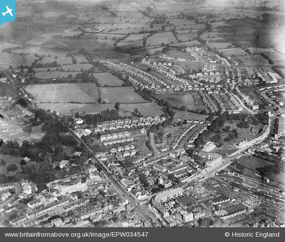
EPW034547 ENGLAND (1930). The High Street and new housing around Manor Park Crescent and environs, Edgware, 1930
    © Copyright OpenStreetMap contributors and licensed by the OpenStreetMap Foundation. 2025. Cartography is licensed as CC BY-SA.
  
Nearby Images (10)
Details
| Title | [EPW034547] The High Street and new housing around Manor Park Crescent and environs, Edgware, 1930 | 
| Reference | EPW034547 | 
| Date | August-1930 | 
| Link | |
| Place name | EDGWARE | 
| Parish | |
| District | |
| Country | ENGLAND | 
| Easting / Northing | 519134, 192103 | 
| Longitude / Latitude | -0.27914151390534, 51.614661705991 | 
| National Grid Reference | TQ191921 | 
Pins
|  Edgware War Memorial |   Captaintee | Sunday 3rd of September 2017 05:02:17 PM | 
| Class31 | Friday 21st of February 2014 12:39:15 PM | |
|  High Street A5 | Class31 | Friday 2nd of August 2013 07:17:16 PM | 
|  Green Lane | Class31 | Friday 2nd of August 2013 07:16:46 PM | 
|  Manor Park Gardens | Class31 | Friday 2nd of August 2013 07:16:29 PM | 
|  Manor Park Crescent | Class31 | Friday 2nd of August 2013 07:15:30 PM | 
|  Hillside Drive | Class31 | Friday 2nd of August 2013 07:14:25 PM | 
|  Hillside Gardens | Class31 | Friday 2nd of August 2013 07:13:41 PM | 
|  Glendale Avenue | Class31 | Friday 2nd of August 2013 07:13:03 PM | 
|  Edgwarebury Gardens | Class31 | Friday 2nd of August 2013 07:12:01 PM | 
| Jazz musician Ronnie Scott lived here in his youth. |   colsouth111 | Saturday 14th of March 2015 01:32:15 PM | 
|  Edgwarebury Lane | Class31 | Friday 2nd of August 2013 07:11:38 PM | 
|  Station Road | Class31 | Friday 2nd of August 2013 07:11:15 PM | 
User Comment Contributions
| Station Road 18/02/2014 | Class31 | Wednesday 30th of April 2014 09:56:05 AM | 
 
             
  ![[EPW034547] The High Street and new housing around Manor Park Crescent and environs, Edgware, 1930](http://britainfromabove.org.uk/sites/all/libraries/aerofilms-images/public/100x100/EPW/034/EPW034547.jpg) 
  
                                          ![[EPW034548] New housing around Stone Grove and environs, Edgware, from the south-west, 1930](http://britainfromabove.org.uk/sites/all/libraries/aerofilms-images/public/100x100/EPW/034/EPW034548.jpg) 
 ![[EPW061138] Stonegrove Park, Green Lane and environs, Edgware, from the north, 1939](http://britainfromabove.org.uk/sites/all/libraries/aerofilms-images/public/100x100/EPW/061/EPW061138.jpg) 
 ![[EPW034556] New housing around Green Lane, Edgware, from the south-east, 1930](http://britainfromabove.org.uk/sites/all/libraries/aerofilms-images/public/100x100/EPW/034/EPW034556.jpg) 
 ![[EPW034550] New housing around Green Lane, Edgware, from the south-west, 1930](http://britainfromabove.org.uk/sites/all/libraries/aerofilms-images/public/100x100/EPW/034/EPW034550.jpg) 
 ![[EAW027667] A Hunting Aerosurveys DH.89A Rapide (G-AEAL) in flight over the Broadfields Avenue area, Edgware, from the south-west, 1949](http://britainfromabove.org.uk/sites/all/libraries/aerofilms-images/public/100x100/EAW/027/EAW027667.jpg) 
 ![[EPW034623] Housing development to the north of the old village, Edgware, from the south-west, 1930](http://britainfromabove.org.uk/sites/all/libraries/aerofilms-images/public/100x100/EPW/034/EPW034623.jpg) 
 ![[EPW034619] Housing development around Green Lane, Edgware, from the south-west, 1930](http://britainfromabove.org.uk/sites/all/libraries/aerofilms-images/public/100x100/EPW/034/EPW034619.jpg) 
 ![[EPW034612] Housing development around the railway stations, Edgware, from the west, 1930](http://britainfromabove.org.uk/sites/all/libraries/aerofilms-images/public/100x100/EPW/034/EPW034612.jpg) 
 ![[EPW034551] Fields at Hill House, Edgware, 1930](http://britainfromabove.org.uk/sites/all/libraries/aerofilms-images/public/100x100/EPW/034/EPW034551.jpg) 
 