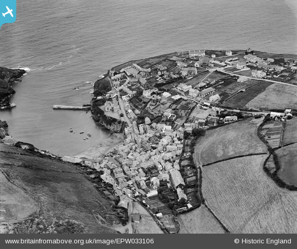
EPW033106 ENGLAND (1930). The Haven and the village, Port Isaac, 1930
© Copyright OpenStreetMap contributors and licensed by the OpenStreetMap Foundation. 2026. Cartography is licensed as CC BY-SA.
Nearby Images (7)
Details
| Title | [EPW033106] The Haven and the village, Port Isaac, 1930 |
| Reference | EPW033106 |
| Date | July-1930 |
| Link | |
| Place name | PORT ISAAC |
| Parish | ST. ENDELLION |
| District | |
| Country | ENGLAND |
| Easting / Northing | 199699, 80836 |
| Longitude / Latitude | -4.8302901597261, 50.592249316059 |
| National Grid Reference | SW997808 |
Pins
Robert Tims |
Wednesday 11th of September 2013 11:07:10 AM |


![[EPW033106] The Haven and the village, Port Isaac, 1930](http://britainfromabove.org.uk/sites/all/libraries/aerofilms-images/public/100x100/EPW/033/EPW033106.jpg)
![[EPW033107] The Haven and the village, Port Isaac, 1930](http://britainfromabove.org.uk/sites/all/libraries/aerofilms-images/public/100x100/EPW/033/EPW033107.jpg)
![[EPW039784] The village and The Haven, Port Isaac, 1932. This image has been produced from a damaged negative.](http://britainfromabove.org.uk/sites/all/libraries/aerofilms-images/public/100x100/EPW/039/EPW039784.jpg)
![[EPW039783] The village and The Haven, Port Isaac, 1932](http://britainfromabove.org.uk/sites/all/libraries/aerofilms-images/public/100x100/EPW/039/EPW039783.jpg)
![[EPW033102] The Haven and the village, Port Isaac, 1930](http://britainfromabove.org.uk/sites/all/libraries/aerofilms-images/public/100x100/EPW/033/EPW033102.jpg)
![[EPW039782] The village, Lobber Point and surrounding coastline, Port Isaac, 1932](http://britainfromabove.org.uk/sites/all/libraries/aerofilms-images/public/100x100/EPW/039/EPW039782.jpg)
![[EPW033105] The village and surrounding countryside, Port Isaac, from the north-east, 1930](http://britainfromabove.org.uk/sites/all/libraries/aerofilms-images/public/100x100/EPW/033/EPW033105.jpg)