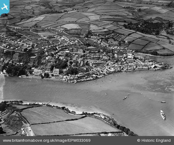
EPW033069 ENGLAND (1930). The town and surrounding countryside, Salcombe, 1930
© Copyright OpenStreetMap contributors and licensed by the OpenStreetMap Foundation. 2025. Cartography is licensed as CC BY-SA.
Nearby Images (9)
Details
| Title | [EPW033069] The town and surrounding countryside, Salcombe, 1930 |
| Reference | EPW033069 |
| Date | July-1930 |
| Link | |
| Place name | SALCOMBE |
| Parish | SALCOMBE |
| District | |
| Country | ENGLAND |
| Easting / Northing | 274055, 38950 |
| Longitude / Latitude | -3.7662598492699, 50.236488296231 |
| National Grid Reference | SX741390 |
Pins
Be the first to add a comment to this image!


![[EPW033069] The town and surrounding countryside, Salcombe, 1930](http://britainfromabove.org.uk/sites/all/libraries/aerofilms-images/public/100x100/EPW/033/EPW033069.jpg)
![[EPW033072] The waterfront, Fore Street and environs, Salcombe, 1930](http://britainfromabove.org.uk/sites/all/libraries/aerofilms-images/public/100x100/EPW/033/EPW033072.jpg)
![[EPW024195] The Salcombe Hotel and adjacent waterfront, Salcombe, 1928](http://britainfromabove.org.uk/sites/all/libraries/aerofilms-images/public/100x100/EPW/024/EPW024195.jpg)
![[EPW024199] The Salcombe Hotel and waterfront, Salcombe, 1928](http://britainfromabove.org.uk/sites/all/libraries/aerofilms-images/public/100x100/EPW/024/EPW024199.jpg)
![[EPW024192] The Salcombe Hotel, King's Arms Quay and Customhouse Quay, Salcombe, 1928](http://britainfromabove.org.uk/sites/all/libraries/aerofilms-images/public/100x100/EPW/024/EPW024192.jpg)
![[EAW007574] Salcombe waterfront and the entrance to Batson Creek, Salcombe, 1947](http://britainfromabove.org.uk/sites/all/libraries/aerofilms-images/public/100x100/EAW/007/EAW007574.jpg)
![[EPW033071] The town and surrounding countryside, Salcombe, 1930](http://britainfromabove.org.uk/sites/all/libraries/aerofilms-images/public/100x100/EPW/033/EPW033071.jpg)
![[EPW033070] The town and surrounding countryside, Salcombe, 1930](http://britainfromabove.org.uk/sites/all/libraries/aerofilms-images/public/100x100/EPW/033/EPW033070.jpg)
![[EPW024219] Holy Trinity Church and environs, Salcombe, 1928](http://britainfromabove.org.uk/sites/all/libraries/aerofilms-images/public/100x100/EPW/024/EPW024219.jpg)