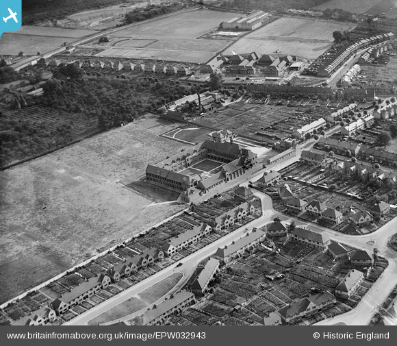
EPW032943 ENGLAND (1930). Maidstone Grammar School, Maidstone, 1930
© Copyright OpenStreetMap contributors and licensed by the OpenStreetMap Foundation. 2026. Cartography is licensed as CC BY-SA.
Nearby Images (9)
Details
| Title | [EPW032943] Maidstone Grammar School, Maidstone, 1930 |
| Reference | EPW032943 |
| Date | June-1930 |
| Link | |
| Place name | MAIDSTONE |
| Parish | |
| District | |
| Country | ENGLAND |
| Easting / Northing | 576642, 154825 |
| Longitude / Latitude | 0.53220978809853, 51.264659448716 |
| National Grid Reference | TQ766548 |
Pins

smokey |
Thursday 13th of January 2022 06:56:57 PM |


![[EPW032943] Maidstone Grammar School, Maidstone, 1930](http://britainfromabove.org.uk/sites/all/libraries/aerofilms-images/public/100x100/EPW/032/EPW032943.jpg)
![[EPW032945] Maidstone Grammar School, Maidstone, 1930](http://britainfromabove.org.uk/sites/all/libraries/aerofilms-images/public/100x100/EPW/032/EPW032945.jpg)
![[EPW032940] Maidstone Grammar School, Maidstone, 1930](http://britainfromabove.org.uk/sites/all/libraries/aerofilms-images/public/100x100/EPW/032/EPW032940.jpg)
![[EPW032942] Maidstone Grammar School and environs, Maidstone, 1930](http://britainfromabove.org.uk/sites/all/libraries/aerofilms-images/public/100x100/EPW/032/EPW032942.jpg)
![[EPW032939] Maidstone Grammar School, Maidstone, 1930](http://britainfromabove.org.uk/sites/all/libraries/aerofilms-images/public/100x100/EPW/032/EPW032939.jpg)
![[EPW032938] Maidstone Grammar School and environs, Maidstone, 1930](http://britainfromabove.org.uk/sites/all/libraries/aerofilms-images/public/100x100/EPW/032/EPW032938.jpg)
![[EPW032944] Maidstone Grammar School and environs, Maidstone, 1930](http://britainfromabove.org.uk/sites/all/libraries/aerofilms-images/public/100x100/EPW/032/EPW032944.jpg)
![[EPW032941] Maidstone Grammar School and playing field, Maidstone, 1930](http://britainfromabove.org.uk/sites/all/libraries/aerofilms-images/public/100x100/EPW/032/EPW032941.jpg)
![[EPW026071] The Foster Clark Estate, Maidstone, 1929](http://britainfromabove.org.uk/sites/all/libraries/aerofilms-images/public/100x100/EPW/026/EPW026071.jpg)