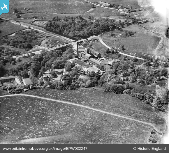
EPW032247 ENGLAND (1930). The Bardsley Vale Mills and Bardsley Bridge, Limehurst, 1930
© Copyright OpenStreetMap contributors and licensed by the OpenStreetMap Foundation. 2026. Cartography is licensed as CC BY-SA.
Nearby Images (10)
Details
| Title | [EPW032247] The Bardsley Vale Mills and Bardsley Bridge, Limehurst, 1930 |
| Reference | EPW032247 |
| Date | June-1930 |
| Link | |
| Place name | LIMEHURST |
| Parish | |
| District | |
| Country | ENGLAND |
| Easting / Northing | 393151, 401301 |
| Longitude / Latitude | -2.1032822011396, 53.508102646109 |
| National Grid Reference | SD932013 |
Pins

boggy |
Saturday 3rd of September 2022 03:33:21 PM | |

MB |
Monday 5th of November 2012 10:51:37 AM | |

MB |
Monday 5th of November 2012 10:50:58 AM | |

MB |
Monday 5th of November 2012 10:50:08 AM | |

MB |
Monday 5th of November 2012 10:49:47 AM | |

MB |
Monday 5th of November 2012 10:48:25 AM | |

MB |
Monday 5th of November 2012 10:45:50 AM | |

MB |
Monday 5th of November 2012 10:44:47 AM | |

MB |
Monday 5th of November 2012 10:42:49 AM | |

MB |
Monday 5th of November 2012 10:42:28 AM | |

MB |
Monday 5th of November 2012 10:41:11 AM | |

MB |
Monday 5th of November 2012 10:40:09 AM | |

MB |
Monday 5th of November 2012 10:39:18 AM | |

MB |
Monday 5th of November 2012 10:37:41 AM | |

MB |
Monday 5th of November 2012 10:37:13 AM |


![[EPW032247] The Bardsley Vale Mills and Bardsley Bridge, Limehurst, 1930](http://britainfromabove.org.uk/sites/all/libraries/aerofilms-images/public/100x100/EPW/032/EPW032247.jpg)
![[EPW032257] The Bardsley Vale Mills and environs, Limehurst, 1930. This image has been produced from a damaged negative.](http://britainfromabove.org.uk/sites/all/libraries/aerofilms-images/public/100x100/EPW/032/EPW032257.jpg)
![[EPW032255] The Bardsley Vale Mills and environs, Limehurst, 1930. This image has been produced from a damaged negative.](http://britainfromabove.org.uk/sites/all/libraries/aerofilms-images/public/100x100/EPW/032/EPW032255.jpg)
![[EPW032249] The Bardsley Vale Mills, the Bardsley Brewery and Bardsley Bridge, Limehurst, 1930. This image has been produced from a damaged negative.](http://britainfromabove.org.uk/sites/all/libraries/aerofilms-images/public/100x100/EPW/032/EPW032249.jpg)
![[EPW032256] The Bardsley Vale Mills, the Stafford Works and Oldham Road, Limehurst, 1930. This image has been produced from a damaged negative.](http://britainfromabove.org.uk/sites/all/libraries/aerofilms-images/public/100x100/EPW/032/EPW032256.jpg)
![[EPW032252] The Bardsley Vale Mills and Lime Hurst Farm, Limehurst, 1930. This image has been produced from a damaged negative.](http://britainfromabove.org.uk/sites/all/libraries/aerofilms-images/public/100x100/EPW/032/EPW032252.jpg)
![[EPW032258] The Bardsley Vale Mills, Oldham Road and the Bardsley Brewery, Limehurst, 1930. This image has been affected by flare.](http://britainfromabove.org.uk/sites/all/libraries/aerofilms-images/public/100x100/EPW/032/EPW032258.jpg)
![[EPW032248] The Bardsley Vale Mills and Bardsley Bridge, Limehurst, 1930. This image has been produced from a damaged negative.](http://britainfromabove.org.uk/sites/all/libraries/aerofilms-images/public/100x100/EPW/032/EPW032248.jpg)
![[EPW032251] The Bardsley Vale Mills, Highfield Terrace and Bardsley Bridge, Limehurst, 1930. This image has been produced from a damaged negative.](http://britainfromabove.org.uk/sites/all/libraries/aerofilms-images/public/100x100/EPW/032/EPW032251.jpg)
![[EPW032254] The Bardsley Vale Mills and Bardsley Bridge, Bardsley, 1930](http://britainfromabove.org.uk/sites/all/libraries/aerofilms-images/public/100x100/EPW/032/EPW032254.jpg)