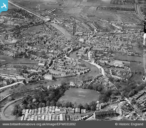
EPW031892 ENGLAND (1930). The Haven, the town and St Botolph's Church, Boston, 1930
    © Copyright OpenStreetMap contributors and licensed by the OpenStreetMap Foundation. 2025. Cartography is licensed as CC BY-SA.
  
Nearby Images (6)
Details
| Title | [EPW031892] The Haven, the town and St Botolph's Church, Boston, 1930 | 
| Reference | EPW031892 | 
| Date | May-1930 | 
| Link | |
| Place name | BOSTON | 
| Parish | |
| District | |
| Country | ENGLAND | 
| Easting / Northing | 532757, 343702 | 
| Longitude / Latitude | -0.022705175135969, 52.973896898937 | 
| National Grid Reference | TF328437 | 
Pins
|  Old towns gas holder |   Isak | Sunday 2nd of November 2014 11:15:11 PM | 
 
             
  ![[EPW031892] The Haven, the town and St Botolph's Church, Boston, 1930](http://britainfromabove.org.uk/sites/all/libraries/aerofilms-images/public/100x100/EPW/031/EPW031892.jpg) 
  
                                          ![[EPW031890] The Haven and the town, Boston, 1930](http://britainfromabove.org.uk/sites/all/libraries/aerofilms-images/public/100x100/EPW/031/EPW031890.jpg) 
 ![[EPW031893] St Aidan's Church, The Haven and environs, Boston, 1930](http://britainfromabove.org.uk/sites/all/libraries/aerofilms-images/public/100x100/EPW/031/EPW031893.jpg) 
 ![[EPW031899] The Haven and the town, Boston, 1930](http://britainfromabove.org.uk/sites/all/libraries/aerofilms-images/public/100x100/EPW/031/EPW031899.jpg) 
 ![[EPW031902] St Botolph's Church, The Haven and the town, Boston, 1930](http://britainfromabove.org.uk/sites/all/libraries/aerofilms-images/public/100x100/EPW/031/EPW031902.jpg) 
 ![[EPW031897] West Street and environs, Boston, 1930](http://britainfromabove.org.uk/sites/all/libraries/aerofilms-images/public/100x100/EPW/031/EPW031897.jpg)