
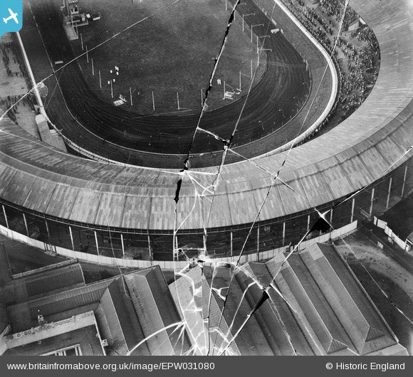
EPW031080 ENGLAND (1929). Shepherd's Bush, a greyhound meeting in progress at the White City Stadium, 1929. This image has been produced from a damaged negative.
© Copyright OpenStreetMap contributors and licensed by the OpenStreetMap Foundation. 2026. Cartography is licensed as CC BY-SA.
Nearby Images (48)
EPW022638

EPW053782

EPW062153

EPW036473

EPW053787

EPW031077

EPW053795

EPW054547

EPW056836

EPW031085

EPW022643

EPW036469

EPW046819

EPW031082

EPW031078

EPW054551

EPW054550

EPW036468

EPW022641

EPW031079

EPW036470

EPW054545

EPW031083

EPW022644

EPW042217
, 1933")
EPW036465

EPW022642

EPW031086

EPW042219
, 1933")
EPW042221
, 1933")
EPW054548

EPW036464

EPW036466

EPW021262

EPW054546

EPW031087

EPW019018

EPW031084

EPW022639

EPW042220
, 1933")
EPW054549

EPW005725

EPW021263

EAW005414

EPW042222
, 1933")
EPW031081

EPW042223
, 1933")
EPW053792

Details
| Title | [EPW031080] Shepherd's Bush, a greyhound meeting in progress at the White City Stadium, 1929. This image has been produced from a damaged negative. |
| Reference | EPW031080 |
| Date | October-1929 |
| Link | |
| Place name | SHEPHERD'S BUSH |
| Parish | |
| District | |
| Country | ENGLAND |
| Easting / Northing | 523165, 180782 |
| Longitude / Latitude | -0.22491208761973, 51.5120399694 |
| National Grid Reference | TQ232808 |
Pins
Be the first to add a comment to this image!