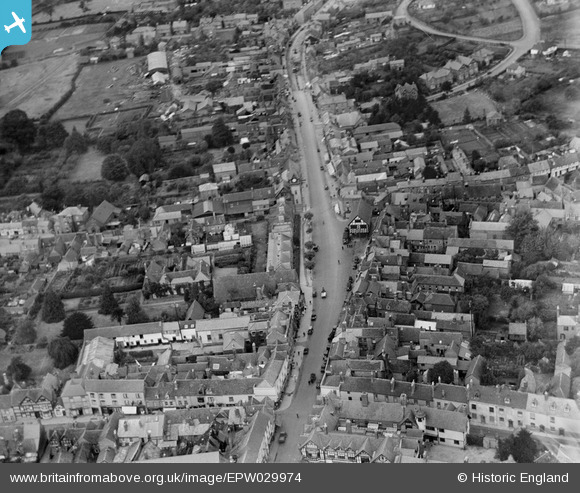
EPW029974 ENGLAND (1929). The High Street, Ledbury, 1929
    © Copyright OpenStreetMap contributors and licensed by the OpenStreetMap Foundation. 2025. Cartography is licensed as CC BY-SA.
  
Nearby Images (7)
Details
| Title | [EPW029974] The High Street, Ledbury, 1929 | 
| Reference | EPW029974 | 
| Date | October-1929 | 
| Link | |
| Place name | LEDBURY | 
| Parish | LEDBURY | 
| District | |
| Country | ENGLAND | 
| Easting / Northing | 371074, 237700 | 
| Longitude / Latitude | -2.4217361138701, 52.036527362137 | 
| National Grid Reference | SO711377 | 
 
             
  ![[EPW029974] The High Street, Ledbury, 1929](http://britainfromabove.org.uk/sites/all/libraries/aerofilms-images/public/100x100/EPW/029/EPW029974.jpg) 
  
                                          ![[EPW029972] The High Street, Ledbury, 1929](http://britainfromabove.org.uk/sites/all/libraries/aerofilms-images/public/100x100/EPW/029/EPW029972.jpg) 
 ![[EPW006031] The High Street and town centre, Ledbury, 1921](http://britainfromabove.org.uk/sites/all/libraries/aerofilms-images/public/100x100/EPW/006/EPW006031.jpg) 
 ![[EPW029968] Bank Crescent and The Homend, Ledbury, 1929. This image has been produced from a copy-negative.](http://britainfromabove.org.uk/sites/all/libraries/aerofilms-images/public/100x100/EPW/029/EPW029968.jpg) 
 ![[EPW029973] St Michael and All Angels Church and the town, Ledbury, 1929](http://britainfromabove.org.uk/sites/all/libraries/aerofilms-images/public/100x100/EPW/029/EPW029973.jpg) 
 ![[EPW029977] New Street, Ledbury, 1929](http://britainfromabove.org.uk/sites/all/libraries/aerofilms-images/public/100x100/EPW/029/EPW029977.jpg) 
 ![[EPW006030] The town centre, Ledbury, from the west, 1921](http://britainfromabove.org.uk/sites/all/libraries/aerofilms-images/public/100x100/EPW/006/EPW006030.jpg) 
  Single-decker bus
 Single-decker bus