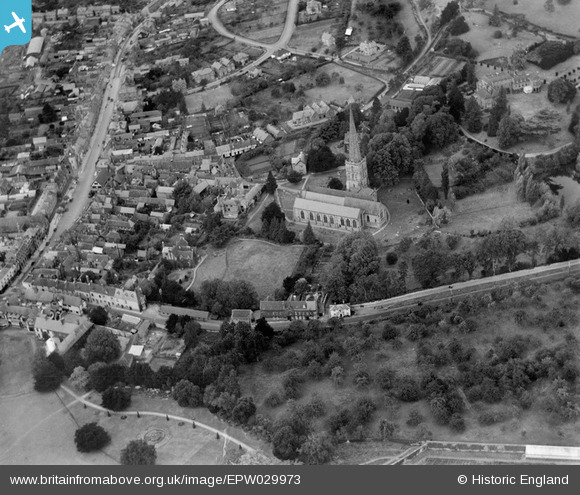
EPW029973 ENGLAND (1929). St Michael and All Angels Church and the town, Ledbury, 1929
    © Copyright OpenStreetMap contributors and licensed by the OpenStreetMap Foundation. 2025. Cartography is licensed as CC BY-SA.
  
Nearby Images (5)
Details
| Title | [EPW029973] St Michael and All Angels Church and the town, Ledbury, 1929 | 
| Reference | EPW029973 | 
| Date | October-1929 | 
| Link | |
| Place name | LEDBURY | 
| Parish | LEDBURY | 
| District | |
| Country | ENGLAND | 
| Easting / Northing | 371250, 237673 | 
| Longitude / Latitude | -2.4191678680786, 52.036293748886 | 
| National Grid Reference | SO713377 | 
Pins
Be the first to add a comment to this image!
 
             
  ![[EPW029973] St Michael and All Angels Church and the town, Ledbury, 1929](http://britainfromabove.org.uk/sites/all/libraries/aerofilms-images/public/100x100/EPW/029/EPW029973.jpg) 
  
                                          ![[EPW006031] The High Street and town centre, Ledbury, 1921](http://britainfromabove.org.uk/sites/all/libraries/aerofilms-images/public/100x100/EPW/006/EPW006031.jpg) 
 ![[EPW029972] The High Street, Ledbury, 1929](http://britainfromabove.org.uk/sites/all/libraries/aerofilms-images/public/100x100/EPW/029/EPW029972.jpg) 
 ![[EPW029974] The High Street, Ledbury, 1929](http://britainfromabove.org.uk/sites/all/libraries/aerofilms-images/public/100x100/EPW/029/EPW029974.jpg) 
 ![[EPW029968] Bank Crescent and The Homend, Ledbury, 1929. This image has been produced from a copy-negative.](http://britainfromabove.org.uk/sites/all/libraries/aerofilms-images/public/100x100/EPW/029/EPW029968.jpg)