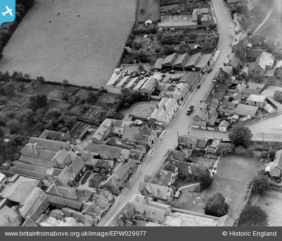
EPW029977 ENGLAND (1929). New Street, Ledbury, 1929
    © Copyright OpenStreetMap contributors and licensed by the OpenStreetMap Foundation. 2025. Cartography is licensed as CC BY-SA.
  
Nearby Images (5)
Details
| Title | [EPW029977] New Street, Ledbury, 1929 | 
| Reference | EPW029977 | 
| Date | October-1929 | 
| Link | |
| Place name | LEDBURY | 
| Parish | LEDBURY | 
| District | |
| Country | ENGLAND | 
| Easting / Northing | 371000, 237507 | 
| Longitude / Latitude | -2.422798619044, 52.034788147799 | 
| National Grid Reference | SO710375 | 
Pins
|  Petrol pump |   MB | Sunday 24th of January 2021 08:52:22 PM | 
 
             
  ![[EPW029977] New Street, Ledbury, 1929](http://britainfromabove.org.uk/sites/all/libraries/aerofilms-images/public/100x100/EPW/029/EPW029977.jpg) 
  
                                          ![[EPW006030] The town centre, Ledbury, from the west, 1921](http://britainfromabove.org.uk/sites/all/libraries/aerofilms-images/public/100x100/EPW/006/EPW006030.jpg) 
 ![[EPW029972] The High Street, Ledbury, 1929](http://britainfromabove.org.uk/sites/all/libraries/aerofilms-images/public/100x100/EPW/029/EPW029972.jpg) 
 ![[EPW006031] The High Street and town centre, Ledbury, 1921](http://britainfromabove.org.uk/sites/all/libraries/aerofilms-images/public/100x100/EPW/006/EPW006031.jpg) 
 ![[EPW029974] The High Street, Ledbury, 1929](http://britainfromabove.org.uk/sites/all/libraries/aerofilms-images/public/100x100/EPW/029/EPW029974.jpg)