
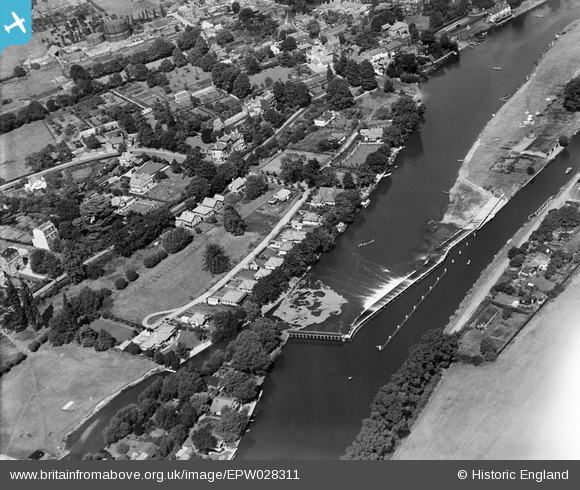
EPW028311 ENGLAND (1929). Sunbury Weir and environs, Sunbury-on-Thames, 1929
© Copyright OpenStreetMap contributors and licensed by the OpenStreetMap Foundation. 2026. Cartography is licensed as CC BY-SA.
Nearby Images (6)
EPW028311

EPW028313

EPW028318

EPW049563

EPW049601

EPW028312

Details
| Title | [EPW028311] Sunbury Weir and environs, Sunbury-on-Thames, 1929 |
| Reference | EPW028311 |
| Date | August-1929 |
| Link | |
| Place name | SUNBURY-ON-THAMES |
| Parish | |
| District | |
| Country | ENGLAND |
| Easting / Northing | 510469, 168186 |
| Longitude / Latitude | -0.41174554133661, 51.401438851796 |
| National Grid Reference | TQ105682 |
Pins

Hanworth1915 |
Wednesday 17th of January 2024 06:17:35 PM | |
|
Hanworth1915 |
Wednesday 17th of January 2024 06:13:40 PM | |
|
Hanworth1915 |
Wednesday 17th of January 2024 06:05:15 PM | |
|
bumblee |
Monday 3rd of February 2020 02:34:58 PM | |
|
bumblee |
Monday 3rd of February 2020 02:34:04 PM | |
|
bumblee |
Wednesday 15th of January 2014 03:30:35 PM | |
I think this building, on the corner of Halliford Road and Thames Street, is Weir House. Weir View was a house opposite St Mary's Church which was demolished by the council c1962 to enlarge to open space known as King's Lawn. |
Hanworth1915 |
Wednesday 17th of January 2024 06:12:47 PM |
|
bumblee |
Wednesday 15th of January 2014 03:29:08 PM | |
|
bumblee |
Wednesday 15th of January 2014 03:27:39 PM |