
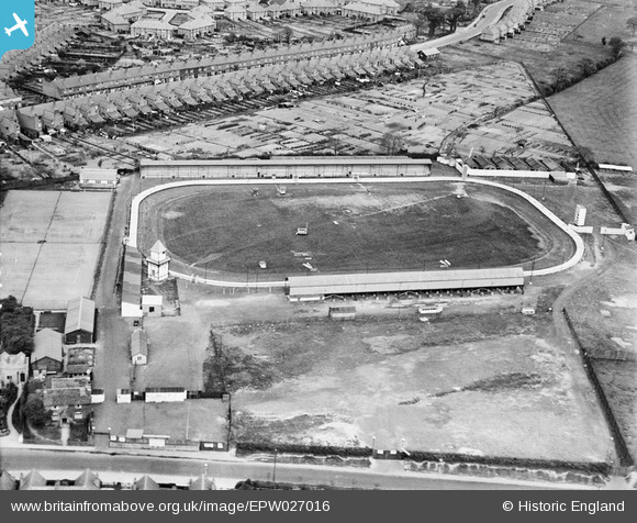
EPW027016 ENGLAND (1929). The Greyhound Stadium, King's Heath, 1929
© Copyright OpenStreetMap contributors and licensed by the OpenStreetMap Foundation. 2026. Cartography is licensed as CC BY-SA.
Nearby Images (13)
EPW027016

EAW032593

EAW032588

EAW032586

EAW032590

EAW032589

EAW032587

EAW032595

EAW032591

EAW032594

EAW032592

EAW032596

EAW032597

Details
| Title | [EPW027016] The Greyhound Stadium, King's Heath, 1929 |
| Reference | EPW027016 |
| Date | May-1929 |
| Link | |
| Place name | KING'S HEATH |
| Parish | |
| District | |
| Country | ENGLAND |
| Easting / Northing | 407591, 280234 |
| Longitude / Latitude | -1.8883679344576, 52.419669197987 |
| National Grid Reference | SP076802 |
Pins
Be the first to add a comment to this image!
User Comment Contributions
Interesting that in its early form the track had four distinct corners with short straights at each end. Later views show a true oval circuit where turn one flows directly into turn two, and three into four. The South Stand burned down in 1933 and had to be replaced. |

gBr |
Monday 30th of November 2015 10:24:51 PM |