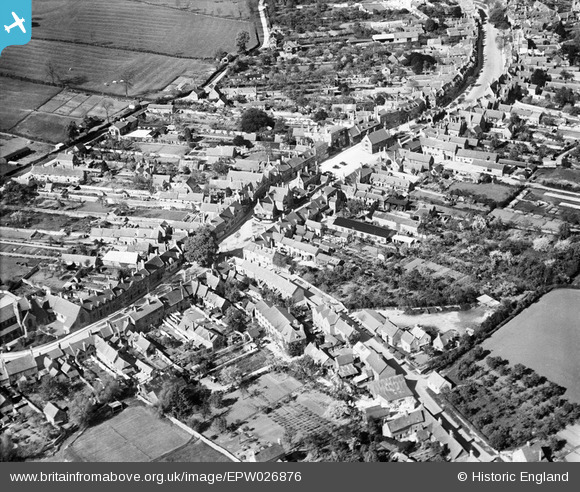
EPW026876 ENGLAND (1929). The town centre, Chipping Campden, 1929
© Copyright OpenStreetMap contributors and licensed by the OpenStreetMap Foundation. 2025. Cartography is licensed as CC BY-SA.
Nearby Images (10)
Details
| Title | [EPW026876] The town centre, Chipping Campden, 1929 |
| Reference | EPW026876 |
| Date | May-1929 |
| Link | |
| Place name | CHIPPING CAMPDEN |
| Parish | CHIPPING CAMPDEN |
| District | |
| Country | ENGLAND |
| Easting / Northing | 414995, 239052 |
| Longitude / Latitude | -1.7813138095832, 52.049235897964 |
| National Grid Reference | SP150391 |
Pins
 georgeegg |
Friday 15th of April 2022 05:01:29 PM |


![[EPW026876] The town centre, Chipping Campden, 1929](http://britainfromabove.org.uk/sites/all/libraries/aerofilms-images/public/100x100/EPW/026/EPW026876.jpg)
![[EAW001659] The Market Place and environs, Chipping Campden, 1946](http://britainfromabove.org.uk/sites/all/libraries/aerofilms-images/public/100x100/EAW/001/EAW001659.jpg)
![[EPW026863] The town centre, Chipping Campden, 1929](http://britainfromabove.org.uk/sites/all/libraries/aerofilms-images/public/100x100/EPW/026/EPW026863.jpg)
![[EAW050106] The town, Chipping Campden, 1953](http://britainfromabove.org.uk/sites/all/libraries/aerofilms-images/public/100x100/EAW/050/EAW050106.jpg)
![[EAW001657] The town, Chipping Campden, from the south-west, 1946](http://britainfromabove.org.uk/sites/all/libraries/aerofilms-images/public/100x100/EAW/001/EAW001657.jpg)
![[EPW026865] St Mary's RC Church and the High Street, Chipping Campden, 1929](http://britainfromabove.org.uk/sites/all/libraries/aerofilms-images/public/100x100/EPW/026/EPW026865.jpg)
![[EPW026868] The town centre, Chipping Campden, 1929](http://britainfromabove.org.uk/sites/all/libraries/aerofilms-images/public/100x100/EPW/026/EPW026868.jpg)
![[EAW050108] The town, Chipping Campden, 1953](http://britainfromabove.org.uk/sites/all/libraries/aerofilms-images/public/100x100/EAW/050/EAW050108.jpg)
![[EPW026862] The town, Chipping Campden, from the south, 1929](http://britainfromabove.org.uk/sites/all/libraries/aerofilms-images/public/100x100/EPW/026/EPW026862.jpg)
![[EAW050107] The town, Chipping Campden, 1953](http://britainfromabove.org.uk/sites/all/libraries/aerofilms-images/public/100x100/EAW/050/EAW050107.jpg)