
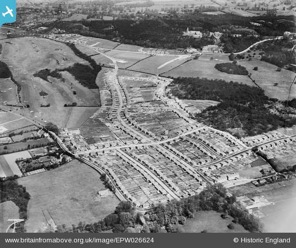
EPW026624 ENGLAND (1929). Croham Hurst Golf Course and a new housing estate at Selsdon, Sanderstead, from the south-east, 1929
© Copyright OpenStreetMap contributors and licensed by the OpenStreetMap Foundation. 2026. Cartography is licensed as CC BY-SA.
Nearby Images (10)
EPW026624

EPW052496

EPW026618

EPW015881

EPW052482

EPW026619

EPW035581

EPW052493

EPW015880

EPW052480

Details
| Title | [EPW026624] Croham Hurst Golf Course and a new housing estate at Selsdon, Sanderstead, from the south-east, 1929 |
| Reference | EPW026624 |
| Date | May-1929 |
| Link | |
| Place name | SANDERSTEAD |
| Parish | |
| District | |
| Country | ENGLAND |
| Easting / Northing | 534761, 162688 |
| Longitude / Latitude | -0.064770543895849, 51.346773585672 |
| National Grid Reference | TQ348627 |
Pins

Class31 |
Saturday 3rd of November 2012 03:12:38 PM | |
|
Class31 |
Saturday 3rd of November 2012 03:12:23 PM | |
|
Class31 |
Saturday 3rd of November 2012 03:11:58 PM | |
|
Class31 |
Saturday 3rd of November 2012 03:11:43 PM | |
|
Class31 |
Saturday 3rd of November 2012 03:11:27 PM | |
|
Class31 |
Saturday 3rd of November 2012 03:11:09 PM | |
|
Class31 |
Saturday 3rd of November 2012 03:10:36 PM | |
|
Class31 |
Saturday 3rd of November 2012 03:10:21 PM | |
|
Class31 |
Saturday 3rd of November 2012 03:10:05 PM |