
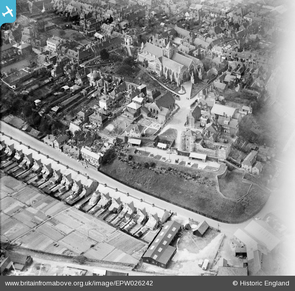
EPW026242 ENGLAND (1929). St Mary's Church, Ypres Tower and environs, Rye, 1929
© Copyright OpenStreetMap contributors and licensed by the OpenStreetMap Foundation. 2026. Cartography is licensed as CC BY-SA.
Nearby Images (8)
EPW026242

EPW026239

EPW000157

EPW026245

EPW026238

EPW039360

EPW035363

EPW039359

Details
| Title | [EPW026242] St Mary's Church, Ypres Tower and environs, Rye, 1929 |
| Reference | EPW026242 |
| Date | 24-April-1929 |
| Link | |
| Place name | RYE |
| Parish | RYE |
| District | |
| Country | ENGLAND |
| Easting / Northing | 592224, 120246 |
| Longitude / Latitude | 0.73689757877159, 50.949002315378 |
| National Grid Reference | TQ922202 |
Pins


User Comment Contributions

Rye Old Bell PH |

Alan McFaden |
Tuesday 26th of August 2014 11:34:34 AM |

Rye East Gate |
Alan McFaden |
Tuesday 26th of August 2014 11:34:06 AM |
Rye |
Alan McFaden |
Tuesday 26th of August 2014 11:33:39 AM |

Rye |
Alan McFaden |
Tuesday 26th of August 2014 11:33:22 AM |

Rye Old Grammar School |
Alan McFaden |
Tuesday 26th of August 2014 11:33:03 AM |