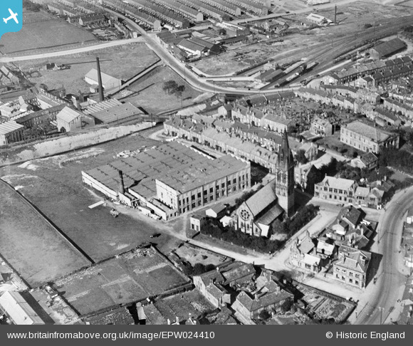
EPW024410 ENGLAND (1928). Westcroft Mill and St John the Evangelist's Church, Great Horton, 1928
© Copyright OpenStreetMap contributors and licensed by the OpenStreetMap Foundation. 2026. Cartography is licensed as CC BY-SA.
Nearby Images (11)
Details
| Title | [EPW024410] Westcroft Mill and St John the Evangelist's Church, Great Horton, 1928 |
| Reference | EPW024410 |
| Date | September-1928 |
| Link | |
| Place name | GREAT HORTON |
| Parish | |
| District | |
| Country | ENGLAND |
| Easting / Northing | 414145, 431676 |
| Longitude / Latitude | -1.7853132733278, 53.781003352956 |
| National Grid Reference | SE141317 |
Pins
User Comment Contributions
Corn Mill Lane runs off the pic centre left now over a narrow railway bridge. The old corn mill was below the level of the railway and originated in the 1300's (Cudworth, Rambles around Horton) |

chrisrob |
Sunday 14th of May 2017 05:08:15 PM |
In the top right is Great Horton railway station and goods yard which closed to passengers in 1955 and to goods in 1965. The road that crosses the railway is Beckside Road. |

AJ427 |
Wednesday 27th of June 2012 04:42:37 PM |


![[EPW024410] Westcroft Mill and St John the Evangelist's Church, Great Horton, 1928](http://britainfromabove.org.uk/sites/all/libraries/aerofilms-images/public/100x100/EPW/024/EPW024410.jpg)
![[EPW052161] Great Horton and Little Horton, Bradford, 1936. This image has been produced from a print.](http://britainfromabove.org.uk/sites/all/libraries/aerofilms-images/public/100x100/EPW/052/EPW052161.jpg)
![[EAW009135] Beckside Worsted Mills at Great Horton, Bradford, 1947. This image was marked by Aerofilms Ltd for photo editing.](http://britainfromabove.org.uk/sites/all/libraries/aerofilms-images/public/100x100/EAW/009/EAW009135.jpg)
![[EAW009132] Beckside Worsted Mills at Great Horton, Bradford, 1947](http://britainfromabove.org.uk/sites/all/libraries/aerofilms-images/public/100x100/EAW/009/EAW009132.jpg)
![[EAW009130] Beckside Worsted Mills at Great Horton, Bradford, 1947](http://britainfromabove.org.uk/sites/all/libraries/aerofilms-images/public/100x100/EAW/009/EAW009130.jpg)
![[EAW009136] Beckside Worsted Mills at Great Horton, Bradford, 1947. This image was marked by Aerofilms Ltd for photo editing.](http://britainfromabove.org.uk/sites/all/libraries/aerofilms-images/public/100x100/EAW/009/EAW009136.jpg)
![[EAW009134] Beckside Worsted Mills at Great Horton, Bradford, 1947](http://britainfromabove.org.uk/sites/all/libraries/aerofilms-images/public/100x100/EAW/009/EAW009134.jpg)
![[EAW009131] Beckside Worsted Mills at Great Horton, Bradford, 1947](http://britainfromabove.org.uk/sites/all/libraries/aerofilms-images/public/100x100/EAW/009/EAW009131.jpg)
![[EAW009128] Beckside Worsted Mills at Great Horton, Bradford, 1947](http://britainfromabove.org.uk/sites/all/libraries/aerofilms-images/public/100x100/EAW/009/EAW009128.jpg)
![[EAW009133] Beckside Worsted Mills at Great Horton, Bradford, 1947. This image was marked by Aerofilms Ltd for photo editing.](http://britainfromabove.org.uk/sites/all/libraries/aerofilms-images/public/100x100/EAW/009/EAW009133.jpg)
![[EAW009129] Beckside Worsted Mills at Great Horton, Bradford, 1947. This image was marked by Aerofilms Ltd for photo editing.](http://britainfromabove.org.uk/sites/all/libraries/aerofilms-images/public/100x100/EAW/009/EAW009129.jpg)