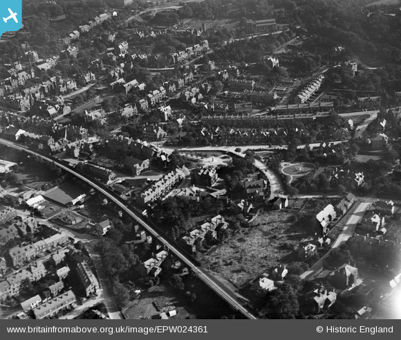
EPW024361 ENGLAND (1928). The Memorial Ground and Spence's Garden, Ilkley, 1928
© Copyright OpenStreetMap contributors and licensed by the OpenStreetMap Foundation. 2025. Cartography is licensed as CC BY-SA.
Nearby Images (5)
Details
| Title | [EPW024361] The Memorial Ground and Spence's Garden, Ilkley, 1928 |
| Reference | EPW024361 |
| Date | September-1928 |
| Link | |
| Place name | ILKLEY |
| Parish | ILKLEY |
| District | |
| Country | ENGLAND |
| Easting / Northing | 411347, 447630 |
| Longitude / Latitude | -1.827190134736, 53.924480614733 |
| National Grid Reference | SE113476 |
Pins
Be the first to add a comment to this image!
User Comment Contributions
Can anyone throw light on the rail track running west out of Ilkley? It appears to be a single track, however Ilkley was a Mainline station in the twenties. |

Freerangeegs |
Monday 24th of March 2014 01:07:28 PM |
The line between Ilkley & Skipton was double track. The northern track is partly obscured in the photo by the shadow of the parapet, but can be seen more clearly at the bottom of the photo. (See Smith & Binns, The Skipon & Ilkley Line). |

Malcolm |
Monday 24th of March 2014 01:07:28 PM |


![[EPW024361] The Memorial Ground and Spence's Garden, Ilkley, 1928](http://britainfromabove.org.uk/sites/all/libraries/aerofilms-images/public/100x100/EPW/024/EPW024361.jpg)
![[EPW024537] Spence's Garden and environs, Ilkley, 1928](http://britainfromabove.org.uk/sites/all/libraries/aerofilms-images/public/100x100/EPW/024/EPW024537.jpg)
![[EPW024402] Grove Road and the Memorial Ground, Ilkley, 1928](http://britainfromabove.org.uk/sites/all/libraries/aerofilms-images/public/100x100/EPW/024/EPW024402.jpg)
![[EPW024364] Ilkley Station and The Grove, Ilkley, 1928](http://britainfromabove.org.uk/sites/all/libraries/aerofilms-images/public/100x100/EPW/024/EPW024364.jpg)
![[EPW024362] Ilkley Station and The Grove, Ilkley, 1928](http://britainfromabove.org.uk/sites/all/libraries/aerofilms-images/public/100x100/EPW/024/EPW024362.jpg)