
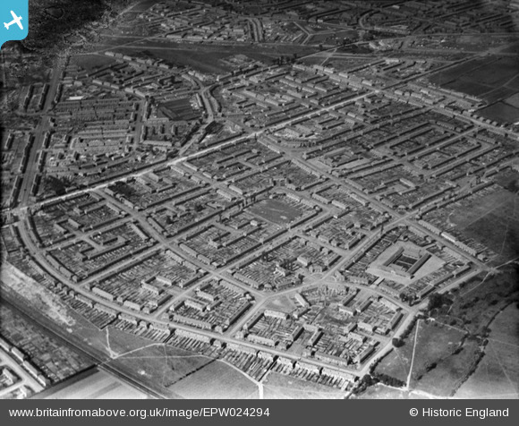
EPW024294 ENGLAND (1928). Housing surrounding Heathway and Albion Road, Becontree, 1928
© Copyright OpenStreetMap contributors and licensed by the OpenStreetMap Foundation. 2026. Cartography is licensed as CC BY-SA.
Nearby Images (3)
EPW024294

EPW024298

EAW043580

Details
| Title | [EPW024294] Housing surrounding Heathway and Albion Road, Becontree, 1928 |
| Reference | EPW024294 |
| Date | September-1928 |
| Link | |
| Place name | BECONTREE |
| Parish | |
| District | |
| Country | ENGLAND |
| Easting / Northing | 549281, 185220 |
| Longitude / Latitude | 0.15309944726723, 51.545623366884 |
| National Grid Reference | TQ493852 |
Pins

Ken Stanton |
Sunday 9th of May 2021 05:44:09 PM | |
|
Ken Stanton |
Sunday 9th of May 2021 05:42:46 PM | |
|
Ken Stanton |
Sunday 9th of May 2021 05:41:46 PM | |
|
ianscarb |
Saturday 1st of March 2014 12:26:47 PM | |
|
ianscarb |
Saturday 1st of March 2014 12:25:07 PM | |
|
ianscarb |
Saturday 1st of March 2014 12:23:37 PM |
User Comment Contributions
The Disrict Line railway is in the bottom left corner of this picture running between Dagenham East (off to the bottom) and Dagenham Heathway(off to the left). Pondfield Park is in the bottom right corner with Pondfield Road to the left of the park. Pondfield Road joins with Reede Road at the bottom right of the picture. Reede Road curves along the left side of the picture and will join with Heathway. Heathway runs from the middle left of the picture to the top right. To the left of the junction of Reede Road and Heathway (off the picture) is Dagenham Heathway station. Opposite Reede Road at Heatway is Parsloes Avenue. To the right of Parsloes Avenue is Fanshawe Crescent where my paternal grand-mother lived. Raydons Road and Halbutt Street are to the right of Fanshawe Crescent. The school in the bottom right corner of the picture is, I think, Hunters Hall Road School where my Dad went to school. Albion Road is at the other end of Pondfield Road and runs bottom right up to and across Heathway to Osborne Road. Albion Road School is on the right about two thirds up before Heathway. |
Ken Stanton |
Saturday 30th of June 2012 05:53:24 PM |