
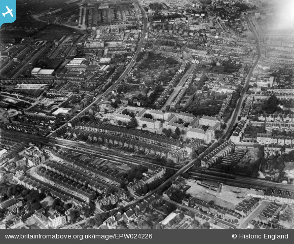
EPW024226 ENGLAND (1928). The Larkhall Estate under construction and environs, Lambeth, 1928
© Copyright OpenStreetMap contributors and licensed by the OpenStreetMap Foundation. 2026. Cartography is licensed as CC BY-SA.
Nearby Images (18)
EPW024226

EPW024228

EPW024229

EAW000475

EPW024227

EPW024225

EPW022809

EAW000470

EAW000471

EAW000473

EAW000474

EPW022806

EPW022808

EPW017169

EAW000472

EPW022807

EPW022820

EPW017173

Details
| Title | [EPW024226] The Larkhall Estate under construction and environs, Lambeth, 1928 |
| Reference | EPW024226 |
| Date | September-1928 |
| Link | |
| Place name | LAMBETH |
| Parish | |
| District | |
| Country | ENGLAND |
| Easting / Northing | 529570, 176234 |
| Longitude / Latitude | -0.13432262830608, 51.469730924671 |
| National Grid Reference | TQ296762 |
Pins

lyndon |
Thursday 2nd of April 2020 09:14:40 PM | |

Class31 |
Tuesday 25th of November 2014 09:17:36 AM | |
|
Class31 |
Tuesday 25th of November 2014 09:16:15 AM | |
|
Class31 |
Tuesday 25th of November 2014 09:14:59 AM | |
|
Class31 |
Tuesday 25th of November 2014 09:13:43 AM | |
|
Class31 |
Tuesday 25th of November 2014 09:12:29 AM | |
|
Class31 |
Tuesday 25th of November 2014 09:11:09 AM | |
|
Class31 |
Tuesday 25th of November 2014 09:09:51 AM | |
|
Class31 |
Tuesday 25th of November 2014 09:08:02 AM | |
|
Class31 |
Tuesday 25th of November 2014 09:05:51 AM | |
|
Class31 |
Monday 24th of November 2014 08:57:52 AM |


User Comment Contributions
Albion Avenue, 08/09/2014 |
Class31 |
Tuesday 25th of November 2014 09:15:28 AM |

Larkhall Rise, 08/09/2014 |
Class31 |
Tuesday 25th of November 2014 09:11:54 AM |

Brayburne Avenue, 08/09/2014 |
Class31 |
Tuesday 25th of November 2014 09:08:37 AM |
My Mother was born in 1928 at Roberts Close Lambeth. Unable to find the address re;googlemaps. Perhaps destroyed in 2nd World War?. |
Jack47 |
Thursday 12th of July 2012 07:38:06 PM |