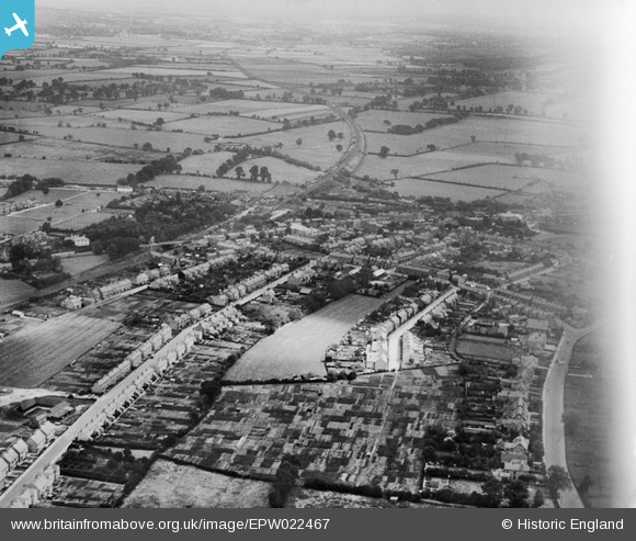
EPW022467 ENGLAND (1928). Western Road and environs, Fenny Stratford, from the south-west, 1928
© Copyright OpenStreetMap contributors and licensed by the OpenStreetMap Foundation. 2026. Cartography is licensed as CC BY-SA.
Details
| Title | [EPW022467] Western Road and environs, Fenny Stratford, from the south-west, 1928 |
| Reference | EPW022467 |
| Date | 9-August-1928 |
| Link | |
| Place name | FENNY STRATFORD |
| Parish | BLETCHLEY AND FENNY STRATFORD |
| District | |
| Country | ENGLAND |
| Easting / Northing | 487702, 233982 |
| Longitude / Latitude | -0.72242579602494, 51.996922488048 |
| National Grid Reference | SP877340 |
Pins

Class31 |
Wednesday 24th of October 2012 11:32:00 PM | |

Class31 |
Wednesday 24th of October 2012 11:31:22 PM | |

Class31 |
Wednesday 24th of October 2012 11:31:22 PM | |

Class31 |
Wednesday 24th of October 2012 11:30:31 PM | |

Class31 |
Wednesday 24th of October 2012 11:30:06 PM | |

Class31 |
Wednesday 24th of October 2012 11:29:31 PM | |

Class31 |
Wednesday 24th of October 2012 11:29:04 PM | |

Class31 |
Wednesday 24th of October 2012 11:28:18 PM | |

Class31 |
Wednesday 24th of October 2012 11:28:00 PM |


![[EPW022467] Western Road and environs, Fenny Stratford, from the south-west, 1928](http://britainfromabove.org.uk/sites/all/libraries/aerofilms-images/public/100x100/EPW/022/EPW022467.jpg)
![[EPW022464] Western Road and environs, Fenny Stratford, 1928](http://britainfromabove.org.uk/sites/all/libraries/aerofilms-images/public/100x100/EPW/022/EPW022464.jpg)
![[EPW056953] Bletchley Road Schools, Fenny Stratford, 1938](http://britainfromabove.org.uk/sites/all/libraries/aerofilms-images/public/100x100/EPW/056/EPW056953.jpg)
![[EPW056950] Bletchley Road (now Queensway), Fenny Stratford, 1938](http://britainfromabove.org.uk/sites/all/libraries/aerofilms-images/public/100x100/EPW/056/EPW056950.jpg)