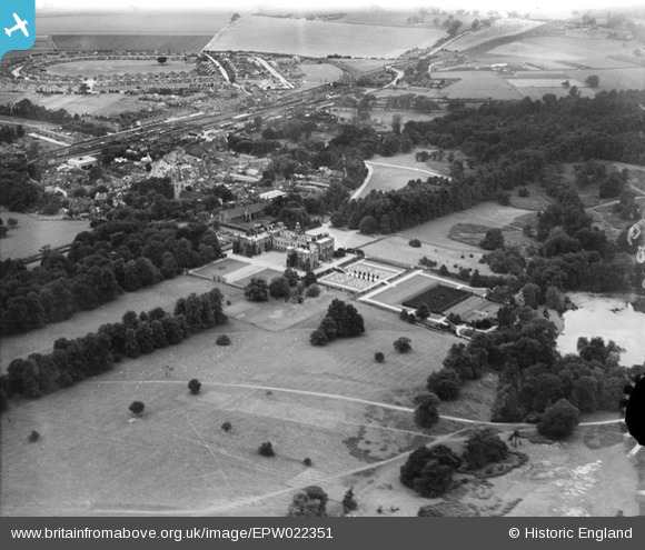
EPW022351 ENGLAND (1928). Hatfield House, Hatfield, 1928
© Copyright OpenStreetMap contributors and licensed by the OpenStreetMap Foundation. 2026. Cartography is licensed as CC BY-SA.
Nearby Images (36)
Details
| Title | [EPW022351] Hatfield House, Hatfield, 1928 |
| Reference | EPW022351 |
| Date | August-1928 |
| Link | |
| Place name | HATFIELD |
| Parish | HATFIELD |
| District | |
| Country | ENGLAND |
| Easting / Northing | 523727, 208388 |
| Longitude / Latitude | -0.20705649446245, 51.760037549345 |
| National Grid Reference | TL237084 |
Pins

Class31 |
Tuesday 27th of May 2014 09:54:45 AM | |

ColinM |
Thursday 11th of April 2013 08:44:00 PM | |

ColinM |
Thursday 11th of April 2013 08:41:10 PM | |

ColinM |
Thursday 11th of April 2013 08:39:40 PM | |

ColinM |
Thursday 11th of April 2013 08:39:00 PM | |

ColinM |
Thursday 11th of April 2013 08:38:19 PM | |

ColinM |
Thursday 11th of April 2013 08:37:29 PM | |

ColinM |
Thursday 11th of April 2013 08:37:07 PM | |

ColinM |
Thursday 11th of April 2013 08:36:27 PM | |

ColinM |
Thursday 11th of April 2013 08:35:24 PM | |

ColinM |
Thursday 11th of April 2013 08:34:41 PM |


![[EPW022351] Hatfield House, Hatfield, 1928](http://britainfromabove.org.uk/sites/all/libraries/aerofilms-images/public/100x100/EPW/022/EPW022351.jpg)
![[EAW014164] Hatfield House, Hatfield, 1948. This image has been produced from a print.](http://britainfromabove.org.uk/sites/all/libraries/aerofilms-images/public/100x100/EAW/014/EAW014164.jpg)
![[EAW042106] Hatfield House, Hatfield, 1952](http://britainfromabove.org.uk/sites/all/libraries/aerofilms-images/public/100x100/EAW/042/EAW042106.jpg)
![[EAW014160] Hatfield House, Hatfield, 1948. This image has been produced from a print.](http://britainfromabove.org.uk/sites/all/libraries/aerofilms-images/public/100x100/EAW/014/EAW014160.jpg)
![[EAW050562] Hatfield House and the surrounding area, Hatfield, 1953](http://britainfromabove.org.uk/sites/all/libraries/aerofilms-images/public/100x100/EAW/050/EAW050562.jpg)
![[EAW014165] Hatfield House, Hatfield, 1948](http://britainfromabove.org.uk/sites/all/libraries/aerofilms-images/public/100x100/EAW/014/EAW014165.jpg)
![[EAW049360] Hatfield House, Hatfield, 1953](http://britainfromabove.org.uk/sites/all/libraries/aerofilms-images/public/100x100/EAW/049/EAW049360.jpg)
![[EAW014167] Hatfield House and Park, Hatfield, from the north-west, 1948. This image has been produced from a print.](http://britainfromabove.org.uk/sites/all/libraries/aerofilms-images/public/100x100/EAW/014/EAW014167.jpg)
![[EPW025381] Hatfield House, Hatfield, 1928](http://britainfromabove.org.uk/sites/all/libraries/aerofilms-images/public/100x100/EPW/025/EPW025381.jpg)
![[EAW014161] Hatfield House, Hatfield, 1948. This image has been produced from a print.](http://britainfromabove.org.uk/sites/all/libraries/aerofilms-images/public/100x100/EAW/014/EAW014161.jpg)
![[EAW053188] Hatfield House, Hatfield, 1954](http://britainfromabove.org.uk/sites/all/libraries/aerofilms-images/public/100x100/EAW/053/EAW053188.jpg)
![[EAW053002] Hatfield House, Hatfield, 1953](http://britainfromabove.org.uk/sites/all/libraries/aerofilms-images/public/100x100/EAW/053/EAW053002.jpg)
![[EAW042111] Hatfield House, Hatfield, 1952](http://britainfromabove.org.uk/sites/all/libraries/aerofilms-images/public/100x100/EAW/042/EAW042111.jpg)
![[EAW049356] Hatfield House and Park, Hatfield, from the west, 1953](http://britainfromabove.org.uk/sites/all/libraries/aerofilms-images/public/100x100/EAW/049/EAW049356.jpg)
![[EAW053192] Hatfield House and environs, Hatfield, from the south, 1954](http://britainfromabove.org.uk/sites/all/libraries/aerofilms-images/public/100x100/EAW/053/EAW053192.jpg)
![[EAW042107] Hatfield House, Hatfield, 1952](http://britainfromabove.org.uk/sites/all/libraries/aerofilms-images/public/100x100/EAW/042/EAW042107.jpg)
![[EAW042110] Hatfield House and the town, Hatfield, from the south-east, 1952](http://britainfromabove.org.uk/sites/all/libraries/aerofilms-images/public/100x100/EAW/042/EAW042110.jpg)
![[EAW036788] The Maze at Hatfield House, Hatfield, 1951. This image has been produced from a copy-negative.](http://britainfromabove.org.uk/sites/all/libraries/aerofilms-images/public/100x100/EAW/036/EAW036788.jpg)
![[EAW050561] Hatfield House and Park, Hatfield, from the north, 1953](http://britainfromabove.org.uk/sites/all/libraries/aerofilms-images/public/100x100/EAW/050/EAW050561.jpg)
![[EAW014162] Hatfield House and Park, Hatfield, from the south, 1948. This image has been produced from a print.](http://britainfromabove.org.uk/sites/all/libraries/aerofilms-images/public/100x100/EAW/014/EAW014162.jpg)
![[EAW049358] Hatfield House and Park, Hatfield, 1953](http://britainfromabove.org.uk/sites/all/libraries/aerofilms-images/public/100x100/EAW/049/EAW049358.jpg)
![[EAW014166] The Maze at Hatfield House, Hatfield, 1948. This image has been produced from a print.](http://britainfromabove.org.uk/sites/all/libraries/aerofilms-images/public/100x100/EAW/014/EAW014166.jpg)
![[EAW049355] Hatfield House, Hatfield, 1953](http://britainfromabove.org.uk/sites/all/libraries/aerofilms-images/public/100x100/EAW/049/EAW049355.jpg)
![[EAW042109] Hatfield House, Hatfield, from the north-east, 1952](http://britainfromabove.org.uk/sites/all/libraries/aerofilms-images/public/100x100/EAW/042/EAW042109.jpg)
![[EAW042108] Hatfield House, Hatfield, from the west, 1952](http://britainfromabove.org.uk/sites/all/libraries/aerofilms-images/public/100x100/EAW/042/EAW042108.jpg)
![[EAW050563] Hatfield House and the surrounding area, Hatfield, 1953](http://britainfromabove.org.uk/sites/all/libraries/aerofilms-images/public/100x100/EAW/050/EAW050563.jpg)
![[EAW053189] Hatfield House, Hatfield, 1954](http://britainfromabove.org.uk/sites/all/libraries/aerofilms-images/public/100x100/EAW/053/EAW053189.jpg)
![[EAW014163] Hatfield House, Hatfield, from the east, 1948. This image has been produced from a print.](http://britainfromabove.org.uk/sites/all/libraries/aerofilms-images/public/100x100/EAW/014/EAW014163.jpg)
![[EAW053190] Hatfield House and Old Hatfield, Hatfield, 1954](http://britainfromabove.org.uk/sites/all/libraries/aerofilms-images/public/100x100/EAW/053/EAW053190.jpg)
![[EAW049361] Hatfield House and environs, Hatfield, 1953](http://britainfromabove.org.uk/sites/all/libraries/aerofilms-images/public/100x100/EAW/049/EAW049361.jpg)
![[EAW049359] Hatfield House and Park, Hatfield, 1953](http://britainfromabove.org.uk/sites/all/libraries/aerofilms-images/public/100x100/EAW/049/EAW049359.jpg)
![[EAW049357] Hatfield House and Park, Hatfield, 1953](http://britainfromabove.org.uk/sites/all/libraries/aerofilms-images/public/100x100/EAW/049/EAW049357.jpg)
![[EAW053191] Hatfield House and Old Hatfield, Hatfield, 1954](http://britainfromabove.org.uk/sites/all/libraries/aerofilms-images/public/100x100/EAW/053/EAW053191.jpg)
![[EAW049354] Hatfield House and environs, Hatfield, 1953](http://britainfromabove.org.uk/sites/all/libraries/aerofilms-images/public/100x100/EAW/049/EAW049354.jpg)
![[EPW025380] St Etheldreda's Church and surroundings, Hatfield, 1928](http://britainfromabove.org.uk/sites/all/libraries/aerofilms-images/public/100x100/EPW/025/EPW025380.jpg)
![[EAW053193] Hatfield House and Old Hatfield, Hatfield, 1954](http://britainfromabove.org.uk/sites/all/libraries/aerofilms-images/public/100x100/EAW/053/EAW053193.jpg)