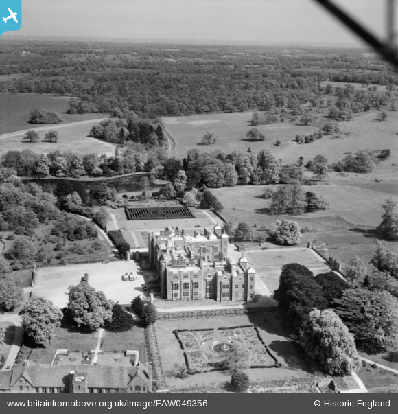
EAW049356 ENGLAND (1953). Hatfield House and Park, Hatfield, from the west, 1953
© Copyright OpenStreetMap contributors and licensed by the OpenStreetMap Foundation. 2026. Cartography is licensed as CC BY-SA.
Nearby Images (37)
Details
| Title | [EAW049356] Hatfield House and Park, Hatfield, from the west, 1953 |
| Reference | EAW049356 |
| Date | 13-May-1953 |
| Link | |
| Place name | HATFIELD |
| Parish | HATFIELD |
| District | |
| Country | ENGLAND |
| Easting / Northing | 523655, 208389 |
| Longitude / Latitude | -0.20809894914468, 51.760062442504 |
| National Grid Reference | TL237084 |
Pins
Be the first to add a comment to this image!


![[EAW049356] Hatfield House and Park, Hatfield, from the west, 1953](http://britainfromabove.org.uk/sites/all/libraries/aerofilms-images/public/100x100/EAW/049/EAW049356.jpg)
![[EAW042107] Hatfield House, Hatfield, 1952](http://britainfromabove.org.uk/sites/all/libraries/aerofilms-images/public/100x100/EAW/042/EAW042107.jpg)
![[EAW014161] Hatfield House, Hatfield, 1948. This image has been produced from a print.](http://britainfromabove.org.uk/sites/all/libraries/aerofilms-images/public/100x100/EAW/014/EAW014161.jpg)
![[EPW025381] Hatfield House, Hatfield, 1928](http://britainfromabove.org.uk/sites/all/libraries/aerofilms-images/public/100x100/EPW/025/EPW025381.jpg)
![[EAW053192] Hatfield House and environs, Hatfield, from the south, 1954](http://britainfromabove.org.uk/sites/all/libraries/aerofilms-images/public/100x100/EAW/053/EAW053192.jpg)
![[EAW014167] Hatfield House and Park, Hatfield, from the north-west, 1948. This image has been produced from a print.](http://britainfromabove.org.uk/sites/all/libraries/aerofilms-images/public/100x100/EAW/014/EAW014167.jpg)
![[EAW053188] Hatfield House, Hatfield, 1954](http://britainfromabove.org.uk/sites/all/libraries/aerofilms-images/public/100x100/EAW/053/EAW053188.jpg)
![[EAW014165] Hatfield House, Hatfield, 1948](http://britainfromabove.org.uk/sites/all/libraries/aerofilms-images/public/100x100/EAW/014/EAW014165.jpg)
![[EAW014160] Hatfield House, Hatfield, 1948. This image has been produced from a print.](http://britainfromabove.org.uk/sites/all/libraries/aerofilms-images/public/100x100/EAW/014/EAW014160.jpg)
![[EAW050563] Hatfield House and the surrounding area, Hatfield, 1953](http://britainfromabove.org.uk/sites/all/libraries/aerofilms-images/public/100x100/EAW/050/EAW050563.jpg)
![[EAW042108] Hatfield House, Hatfield, from the west, 1952](http://britainfromabove.org.uk/sites/all/libraries/aerofilms-images/public/100x100/EAW/042/EAW042108.jpg)
![[EAW042106] Hatfield House, Hatfield, 1952](http://britainfromabove.org.uk/sites/all/libraries/aerofilms-images/public/100x100/EAW/042/EAW042106.jpg)
![[EAW014164] Hatfield House, Hatfield, 1948. This image has been produced from a print.](http://britainfromabove.org.uk/sites/all/libraries/aerofilms-images/public/100x100/EAW/014/EAW014164.jpg)
![[EPW022351] Hatfield House, Hatfield, 1928](http://britainfromabove.org.uk/sites/all/libraries/aerofilms-images/public/100x100/EPW/022/EPW022351.jpg)
![[EAW053002] Hatfield House, Hatfield, 1953](http://britainfromabove.org.uk/sites/all/libraries/aerofilms-images/public/100x100/EAW/053/EAW053002.jpg)
![[EAW053190] Hatfield House and Old Hatfield, Hatfield, 1954](http://britainfromabove.org.uk/sites/all/libraries/aerofilms-images/public/100x100/EAW/053/EAW053190.jpg)
![[EAW049361] Hatfield House and environs, Hatfield, 1953](http://britainfromabove.org.uk/sites/all/libraries/aerofilms-images/public/100x100/EAW/049/EAW049361.jpg)
![[EAW053191] Hatfield House and Old Hatfield, Hatfield, 1954](http://britainfromabove.org.uk/sites/all/libraries/aerofilms-images/public/100x100/EAW/053/EAW053191.jpg)
![[EAW014162] Hatfield House and Park, Hatfield, from the south, 1948. This image has been produced from a print.](http://britainfromabove.org.uk/sites/all/libraries/aerofilms-images/public/100x100/EAW/014/EAW014162.jpg)
![[EAW050562] Hatfield House and the surrounding area, Hatfield, 1953](http://britainfromabove.org.uk/sites/all/libraries/aerofilms-images/public/100x100/EAW/050/EAW050562.jpg)
![[EAW042110] Hatfield House and the town, Hatfield, from the south-east, 1952](http://britainfromabove.org.uk/sites/all/libraries/aerofilms-images/public/100x100/EAW/042/EAW042110.jpg)
![[EAW049360] Hatfield House, Hatfield, 1953](http://britainfromabove.org.uk/sites/all/libraries/aerofilms-images/public/100x100/EAW/049/EAW049360.jpg)
![[EAW053189] Hatfield House, Hatfield, 1954](http://britainfromabove.org.uk/sites/all/libraries/aerofilms-images/public/100x100/EAW/053/EAW053189.jpg)
![[EAW049354] Hatfield House and environs, Hatfield, 1953](http://britainfromabove.org.uk/sites/all/libraries/aerofilms-images/public/100x100/EAW/049/EAW049354.jpg)
![[EAW050561] Hatfield House and Park, Hatfield, from the north, 1953](http://britainfromabove.org.uk/sites/all/libraries/aerofilms-images/public/100x100/EAW/050/EAW050561.jpg)
![[EAW049355] Hatfield House, Hatfield, 1953](http://britainfromabove.org.uk/sites/all/libraries/aerofilms-images/public/100x100/EAW/049/EAW049355.jpg)
![[EAW042111] Hatfield House, Hatfield, 1952](http://britainfromabove.org.uk/sites/all/libraries/aerofilms-images/public/100x100/EAW/042/EAW042111.jpg)
![[EAW036788] The Maze at Hatfield House, Hatfield, 1951. This image has been produced from a copy-negative.](http://britainfromabove.org.uk/sites/all/libraries/aerofilms-images/public/100x100/EAW/036/EAW036788.jpg)
![[EAW049358] Hatfield House and Park, Hatfield, 1953](http://britainfromabove.org.uk/sites/all/libraries/aerofilms-images/public/100x100/EAW/049/EAW049358.jpg)
![[EPW025380] St Etheldreda's Church and surroundings, Hatfield, 1928](http://britainfromabove.org.uk/sites/all/libraries/aerofilms-images/public/100x100/EPW/025/EPW025380.jpg)
![[EAW014166] The Maze at Hatfield House, Hatfield, 1948. This image has been produced from a print.](http://britainfromabove.org.uk/sites/all/libraries/aerofilms-images/public/100x100/EAW/014/EAW014166.jpg)
![[EAW042109] Hatfield House, Hatfield, from the north-east, 1952](http://britainfromabove.org.uk/sites/all/libraries/aerofilms-images/public/100x100/EAW/042/EAW042109.jpg)
![[EAW014163] Hatfield House, Hatfield, from the east, 1948. This image has been produced from a print.](http://britainfromabove.org.uk/sites/all/libraries/aerofilms-images/public/100x100/EAW/014/EAW014163.jpg)
![[EAW049357] Hatfield House and Park, Hatfield, 1953](http://britainfromabove.org.uk/sites/all/libraries/aerofilms-images/public/100x100/EAW/049/EAW049357.jpg)
![[EAW053003] St Ethelreda's Church, Hatfield, 1953](http://britainfromabove.org.uk/sites/all/libraries/aerofilms-images/public/100x100/EAW/053/EAW053003.jpg)
![[EAW053193] Hatfield House and Old Hatfield, Hatfield, 1954](http://britainfromabove.org.uk/sites/all/libraries/aerofilms-images/public/100x100/EAW/053/EAW053193.jpg)
![[EAW049359] Hatfield House and Park, Hatfield, 1953](http://britainfromabove.org.uk/sites/all/libraries/aerofilms-images/public/100x100/EAW/049/EAW049359.jpg)