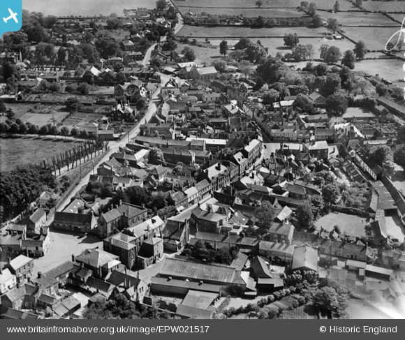
EPW021517 ENGLAND (1928). The town centre, Downham Market, 1928
© Copyright OpenStreetMap contributors and licensed by the OpenStreetMap Foundation. 2025. Cartography is licensed as CC BY-SA.
Nearby Images (10)
Details
| Title | [EPW021517] The town centre, Downham Market, 1928 |
| Reference | EPW021517 |
| Date | June-1928 |
| Link | |
| Place name | DOWNHAM MARKET |
| Parish | DOWNHAM MARKET |
| District | |
| Country | ENGLAND |
| Easting / Northing | 561152, 303241 |
| Longitude / Latitude | 0.37991912999187, 52.602664523409 |
| National Grid Reference | TF612032 |
Pins

Mike B |
Sunday 23rd of September 2012 03:56:01 PM | |

Mike B |
Sunday 23rd of September 2012 03:55:23 PM | |

Mike B |
Sunday 23rd of September 2012 03:53:14 PM | |

Mike B |
Sunday 23rd of September 2012 03:50:47 PM | |

Mike B |
Sunday 23rd of September 2012 03:29:06 PM | |

Mike B |
Sunday 23rd of September 2012 03:26:28 PM |


![[EPW021517] The town centre, Downham Market, 1928](http://britainfromabove.org.uk/sites/all/libraries/aerofilms-images/public/100x100/EPW/021/EPW021517.jpg)
![[EAW031885] The town centre, Downham Market, 1950](http://britainfromabove.org.uk/sites/all/libraries/aerofilms-images/public/100x100/EAW/031/EAW031885.jpg)
![[EAW031886] The town, Downham Market, 1950](http://britainfromabove.org.uk/sites/all/libraries/aerofilms-images/public/100x100/EAW/031/EAW031886.jpg)
![[EAW031887] The town, Downham Market, 1950](http://britainfromabove.org.uk/sites/all/libraries/aerofilms-images/public/100x100/EAW/031/EAW031887.jpg)
![[EAW055113] The town centre, Downham Market, 1954](http://britainfromabove.org.uk/sites/all/libraries/aerofilms-images/public/100x100/EAW/055/EAW055113.jpg)
![[EAW031884] The town, Downham Market, 1950](http://britainfromabove.org.uk/sites/all/libraries/aerofilms-images/public/100x100/EAW/031/EAW031884.jpg)
![[EPW021463] The Town Centre, Downham Market, 1928](http://britainfromabove.org.uk/sites/all/libraries/aerofilms-images/public/100x100/EPW/021/EPW021463.jpg)
![[EPW021518] Cannon Square and environs, Downham Market, 1928](http://britainfromabove.org.uk/sites/all/libraries/aerofilms-images/public/100x100/EPW/021/EPW021518.jpg)
![[EPW021515] Church Road and environs, Downham Market, 1928](http://britainfromabove.org.uk/sites/all/libraries/aerofilms-images/public/100x100/EPW/021/EPW021515.jpg)
![[EPW021514] Bridge Street and environs, Downham Market, 1928](http://britainfromabove.org.uk/sites/all/libraries/aerofilms-images/public/100x100/EPW/021/EPW021514.jpg)