
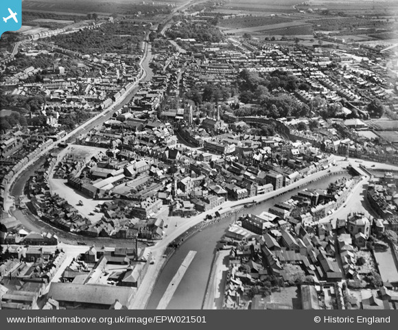
EPW021501 ENGLAND (1928). The town centre, Wisbech, from the north-west, 1928
© Copyright OpenStreetMap contributors and licensed by the OpenStreetMap Foundation. 2026. Cartography is licensed as CC BY-SA.
Nearby Images (5)
EPW021501

EPW021503

EPW021500

EPW021507

EPW039184

Details
| Title | [EPW021501] The town centre, Wisbech, from the north-west, 1928 |
| Reference | EPW021501 |
| Date | June-1928 |
| Link | |
| Place name | WISBECH |
| Parish | WISBECH |
| District | |
| Country | ENGLAND |
| Easting / Northing | 546116, 309903 |
| Longitude / Latitude | 0.16099388036593, 52.666770537024 |
| National Grid Reference | TF461099 |
Pins

Jon Ward |
Thursday 1st of March 2018 02:52:11 AM | |
|
Peter |
Wednesday 19th of August 2015 09:34:10 PM | |
|
pf329 |
Saturday 11th of July 2015 05:42:29 PM | |
|
Peter |
Thursday 1st of January 2015 06:24:47 PM | |
|
Peter |
Thursday 1st of January 2015 06:21:31 PM | |
|
Peter |
Friday 28th of December 2012 08:18:39 PM | |
|
Peter |
Friday 28th of December 2012 08:17:48 PM | |
|
Peter |
Friday 28th of December 2012 08:16:41 PM | |
|
Peter |
Friday 28th of December 2012 08:08:38 PM | |
|
Peter |
Friday 28th of December 2012 07:04:01 PM | |
|
Peter |
Friday 28th of December 2012 07:03:06 PM | |
|
Peter |
Friday 28th of December 2012 07:01:40 PM | |
It never ever was the South Station. It was always the East Station. |
snapper31 |
Friday 17th of May 2013 02:17:03 PM |
|
Peter |
Friday 28th of December 2012 06:34:28 PM | |
|
Peter |
Friday 28th of December 2012 06:32:38 PM | |
|
Peter |
Friday 28th of December 2012 06:28:41 PM | |
|
Peter |
Friday 28th of December 2012 06:27:51 PM |