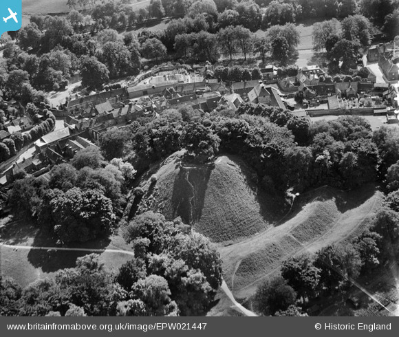
EPW021447 ENGLAND (1928). Castle Hill, Thetford, 1928

© Copyright OpenStreetMap contributors and licensed by the OpenStreetMap Foundation. 2024. Cartography is licensed as CC BY-SA.

Nearby Images (4)

EPW021447
  0° 0m
EPW021452
  0° 22m
EPW039260
  302° 232m
EPW021457
  313° 314m

Details

Title [EPW021447] Castle Hill, Thetford, 1928
Reference EPW021447
Date 13-June-1928
Link
Place name THETFORD
Parish THETFORD
District
Country ENGLAND
Easting / Northing 587390, 282819
Longitude / Latitude 0.7554491847924, 52.410849990307
National Grid Reference TL874828

Pins

This building is known as The Old Malting. Not known exactly when it was built but must have been after 1786. It was owned by a member of the Bidwell family and in the 1950s and 60s was Thetford's youth centre. Now converted into residential accommodation.

d.osborne
Wednesday 22nd of April 2015 03:45:13 AM
This house standing in Nether Row was once the Victoria Shades beer house and belonged to the brewery of W.W. Wicks. The Shades was later taken over by Thetford brewer Bidwell. The Shades closed in 1905. The site of Wicks former Brewery is just out of view to the west or right edge of the photo.

d.osborne
Sunday 19th of April 2015 05:39:59 PM
The River Thet. The outer defences of the Castle Hill are believed to have once extended to the river. The Thet joins the Little Ouse river in the centre of the town just a few metres east of the Town Bridge.

d.osborne
Sunday 19th of April 2015 05:31:40 PM
The Castle Hill. Once the subject of much conjecture as to its origins. From archaeological excavations in 1962 it is believed that the Castle Hill was originally an Iron Age hillfort built about 500BC. At some time soon after the Norman Conquest it was modified into the large 'Motte' that we see today. No evidence of a castle was found on the summit of the 'motte' so if there was a castle it was most probably constructed of wood. The system of outer ditches and banks that survive are of Iron Age origin.

d.osborne
Sunday 19th of April 2015 05:28:25 PM
The Gaol. Possible that a gaol has stood on or very close to this site since the end of the 13th century. Little detail is known of the Gaol until the late 18th century after it was described by the prison reformer John Howard. After it ceased as a gaol and house of correction in the 19th century it was Thetford's Police Station until 1936 when a new police station was built and opened on the Norwich Road.

d.osborne
Sunday 19th of April 2015 05:20:31 PM
Old Market Street. The area between Ford Street and Old Market Street was Thetford's medieval market place. The old Market Cross was taken down and the market removed to a more central position in the town in 1786.

d.osborne
Sunday 19th of April 2015 05:15:42 PM
This house was built late 18th century for James Mingay and named New Place. Later named as The Rookery and demolished to make way for flats in early 1960s.

d.osborne
Sunday 19th of April 2015 05:13:00 PM
Bidwell's Brewery. Purchased by Bullards of Norwich in 1924 and closed.

d.osborne
Sunday 19th of April 2015 05:07:56 PM
The site of Vipan's Brewery, sold in 1837 after the death of Thomas Vipan. Now a garden.

d.osborne
Sunday 19th of April 2015 05:06:26 PM
Ford Street, formerly Gaol Street 19thC.

d.osborne
Sunday 19th of April 2015 05:04:02 PM