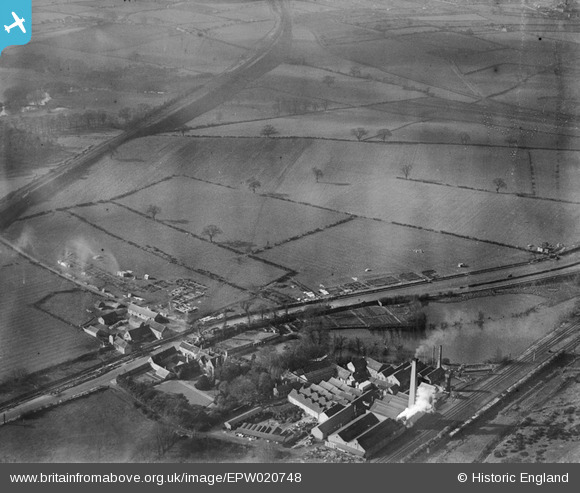
EPW020748 ENGLAND (1928). The site of the Bulwell Hall Estate, Bulwell, 1928
© Copyright OpenStreetMap contributors and licensed by the OpenStreetMap Foundation. 2026. Cartography is licensed as CC BY-SA.
Nearby Images (41)
Details
| Title | [EPW020748] The site of the Bulwell Hall Estate, Bulwell, 1928 |
| Reference | EPW020748 |
| Date | March-1928 |
| Link | |
| Place name | BULWELL |
| Parish | |
| District | |
| Country | ENGLAND |
| Easting / Northing | 454457, 346423 |
| Longitude / Latitude | -1.1882343590605, 53.012033487693 |
| National Grid Reference | SK545464 |
Pins
Be the first to add a comment to this image!


![[EPW020748] The site of the Bulwell Hall Estate, Bulwell, 1928](http://britainfromabove.org.uk/sites/all/libraries/aerofilms-images/public/100x100/EPW/020/EPW020748.jpg)
![[EPW020738] The site of the Bulwell Hall Estate, Bulwell, from the south-east, 1928](http://britainfromabove.org.uk/sites/all/libraries/aerofilms-images/public/100x100/EPW/020/EPW020738.jpg)
![[EAW031320] The Springfield Hosiery Finishing Co Ltd Works, Bulwell, 1950](http://britainfromabove.org.uk/sites/all/libraries/aerofilms-images/public/100x100/EAW/031/EAW031320.jpg)
![[EPW021093] Bleaching Works, Bulwell, 1928](http://britainfromabove.org.uk/sites/all/libraries/aerofilms-images/public/100x100/EPW/021/EPW021093.jpg)
![[EAW031317] The Springfield Hosiery Finishing Co Ltd Works and Moor Bridge, Bulwell, 1950. This image was marked by Aerofilms Ltd for photo editing.](http://britainfromabove.org.uk/sites/all/libraries/aerofilms-images/public/100x100/EAW/031/EAW031317.jpg)
![[EAW031319] The Springfield Hosiery Finishing Co Ltd Works, Bulwell, 1950](http://britainfromabove.org.uk/sites/all/libraries/aerofilms-images/public/100x100/EAW/031/EAW031319.jpg)
![[EPW021090] Bleaching Works, Bulwell, 1928](http://britainfromabove.org.uk/sites/all/libraries/aerofilms-images/public/100x100/EPW/021/EPW021090.jpg)
![[EPW021092] Bleaching Works, Bulwell, 1928](http://britainfromabove.org.uk/sites/all/libraries/aerofilms-images/public/100x100/EPW/021/EPW021092.jpg)
![[EPW021086] Bleaching Works, Bulwell, 1928](http://britainfromabove.org.uk/sites/all/libraries/aerofilms-images/public/100x100/EPW/021/EPW021086.jpg)
![[EPW021094] Bleaching Works, Bulwell, 1928](http://britainfromabove.org.uk/sites/all/libraries/aerofilms-images/public/100x100/EPW/021/EPW021094.jpg)
![[EPW021091] Bleaching Works, Bulwell, 1928](http://britainfromabove.org.uk/sites/all/libraries/aerofilms-images/public/100x100/EPW/021/EPW021091.jpg)
![[EAW031316] The Springfield Hosiery Finishing Co Ltd Works, Bulwell, 1950. This image was marked by Aerofilms Ltd for photo editing.](http://britainfromabove.org.uk/sites/all/libraries/aerofilms-images/public/100x100/EAW/031/EAW031316.jpg)
![[EPW021087] Bleaching Works, Bulwell, 1928](http://britainfromabove.org.uk/sites/all/libraries/aerofilms-images/public/100x100/EPW/021/EPW021087.jpg)
![[EAW031318] The Springfield Hosiery Finishing Co Ltd Works and Moor Bridge, Bulwell, 1950. This image was marked by Aerofilms Ltd for photo editing.](http://britainfromabove.org.uk/sites/all/libraries/aerofilms-images/public/100x100/EAW/031/EAW031318.jpg)
![[EPW021089] Bleaching Works, Bulwell, 1928](http://britainfromabove.org.uk/sites/all/libraries/aerofilms-images/public/100x100/EPW/021/EPW021089.jpg)
![[EPW021088] Bleaching Works, Bulwell, 1928](http://britainfromabove.org.uk/sites/all/libraries/aerofilms-images/public/100x100/EPW/021/EPW021088.jpg)
![[EPW021809] Bleaching Works, Bulwell, 1928](http://britainfromabove.org.uk/sites/all/libraries/aerofilms-images/public/100x100/EPW/021/EPW021809.jpg)
![[EPW021807] Bleaching Works, Bulwell, 1928](http://britainfromabove.org.uk/sites/all/libraries/aerofilms-images/public/100x100/EPW/021/EPW021807.jpg)
![[EAW031322] The Springfield Hosiery Finishing Co Ltd Works, Bulwell, 1950. This image was marked by Aerofilms Ltd for photo editing.](http://britainfromabove.org.uk/sites/all/libraries/aerofilms-images/public/100x100/EAW/031/EAW031322.jpg)
![[EAW031325] The Springfield Hosiery Finishing Co Ltd Works, Bulwell, 1950. This image was marked by Aerofilms Ltd for photo editing.](http://britainfromabove.org.uk/sites/all/libraries/aerofilms-images/public/100x100/EAW/031/EAW031325.jpg)
![[EPW021810] Bleaching Works, Bulwell, 1928](http://britainfromabove.org.uk/sites/all/libraries/aerofilms-images/public/100x100/EPW/021/EPW021810.jpg)
![[EPW034149] The Bulwell Hall Estate, Bulwell, 1930](http://britainfromabove.org.uk/sites/all/libraries/aerofilms-images/public/100x100/EPW/034/EPW034149.jpg)
![[EAW031321] The Springfield Hosiery Finishing Co Ltd Works and Hucknall Lane, Bulwell, 1950. This image was marked by Aerofilms Ltd for photo editing.](http://britainfromabove.org.uk/sites/all/libraries/aerofilms-images/public/100x100/EAW/031/EAW031321.jpg)
![[EAW031323] The Springfield Hosiery Finishing Co Ltd Works and Hucknall Lane, Bulwell, 1950. This image was marked by Aerofilms Ltd for photo editing.](http://britainfromabove.org.uk/sites/all/libraries/aerofilms-images/public/100x100/EAW/031/EAW031323.jpg)
![[EPW020744] The site of the Bulwell Hall Estate, Bulwell, 1928](http://britainfromabove.org.uk/sites/all/libraries/aerofilms-images/public/100x100/EPW/020/EPW020744.jpg)
![[EPW020740] The site of the Bulwell Hall Estate, Bulwell, 1928](http://britainfromabove.org.uk/sites/all/libraries/aerofilms-images/public/100x100/EPW/020/EPW020740.jpg)
![[EAW031324] The Springfield Hosiery Finishing Co Ltd Works, Bulwell, 1950. This image was marked by Aerofilms Ltd for photo editing.](http://britainfromabove.org.uk/sites/all/libraries/aerofilms-images/public/100x100/EAW/031/EAW031324.jpg)
![[EPW021808] Bleaching Works, Bulwell, 1928](http://britainfromabove.org.uk/sites/all/libraries/aerofilms-images/public/100x100/EPW/021/EPW021808.jpg)
![[EPW034142] The Bulwell Hall Estate, Bulwell, from the south-east, 1930](http://britainfromabove.org.uk/sites/all/libraries/aerofilms-images/public/100x100/EPW/034/EPW034142.jpg)
![[EPW020743] The site of the Bulwell Hall Estate, Bulwell, 1928](http://britainfromabove.org.uk/sites/all/libraries/aerofilms-images/public/100x100/EPW/020/EPW020743.jpg)
![[EPW020737] The site of the Bulwell Hall Estate, Bulwell, 1928](http://britainfromabove.org.uk/sites/all/libraries/aerofilms-images/public/100x100/EPW/020/EPW020737.jpg)
![[EPW034147] The Bulwell Hall Estate, Bulwell, 1930](http://britainfromabove.org.uk/sites/all/libraries/aerofilms-images/public/100x100/EPW/034/EPW034147.jpg)
![[EPW034135] The Bulwell Hall Estate, Bulwell, from the south-west, 1930](http://britainfromabove.org.uk/sites/all/libraries/aerofilms-images/public/100x100/EPW/034/EPW034135.jpg)
![[EPW034148] The Bulwell Hall Estate, Bulwell, 1930](http://britainfromabove.org.uk/sites/all/libraries/aerofilms-images/public/100x100/EPW/034/EPW034148.jpg)
![[EPW034137] The Bulwell Hall Estate, Bulwell, 1930](http://britainfromabove.org.uk/sites/all/libraries/aerofilms-images/public/100x100/EPW/034/EPW034137.jpg)
![[EPW020739] The site of the Bulwell Hall Estate, Bulwell, from the south-east, 1928](http://britainfromabove.org.uk/sites/all/libraries/aerofilms-images/public/100x100/EPW/020/EPW020739.jpg)
![[EPW034136] The Bulwell Hall Estate, Bulwell, from the east 1930](http://britainfromabove.org.uk/sites/all/libraries/aerofilms-images/public/100x100/EPW/034/EPW034136.jpg)
![[EPW020742] The site of the Bulwell Hall Estate, Bulwell, 1928](http://britainfromabove.org.uk/sites/all/libraries/aerofilms-images/public/100x100/EPW/020/EPW020742.jpg)
![[EPW034143] The Bulwell Hall Estate, Bulwell, from the east, 1930](http://britainfromabove.org.uk/sites/all/libraries/aerofilms-images/public/100x100/EPW/034/EPW034143.jpg)
![[EAW038724] Grindon Crescent and Bulwell Hall Park, Bulwell, 1951. This image has been produced from a print.](http://britainfromabove.org.uk/sites/all/libraries/aerofilms-images/public/100x100/EAW/038/EAW038724.jpg)
![[EPW020741] The site of the Bulwell Hall Estate, Bulwell, 1928](http://britainfromabove.org.uk/sites/all/libraries/aerofilms-images/public/100x100/EPW/020/EPW020741.jpg)