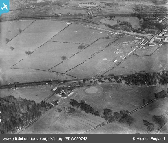
EPW020742 ENGLAND (1928). The site of the Bulwell Hall Estate, Bulwell, 1928
© Copyright OpenStreetMap contributors and licensed by the OpenStreetMap Foundation. 2026. Cartography is licensed as CC BY-SA.
Nearby Images (18)
Details
| Title | [EPW020742] The site of the Bulwell Hall Estate, Bulwell, 1928 |
| Reference | EPW020742 |
| Date | March-1928 |
| Link | |
| Place name | BULWELL |
| Parish | |
| District | |
| Country | ENGLAND |
| Easting / Northing | 454216, 346491 |
| Longitude / Latitude | -1.1918150244804, 53.012669224788 |
| National Grid Reference | SK542465 |
Pins

tmac |
Wednesday 7th of December 2016 12:11:56 PM | |

tmac |
Wednesday 7th of December 2016 12:09:47 PM | |

tmac |
Wednesday 7th of December 2016 12:05:49 PM | |

tmac |
Wednesday 7th of December 2016 11:59:17 AM | |

John Wass |
Sunday 14th of June 2015 03:09:13 PM | |
this was known as bulwell hall halt and is on the great central railway |

tmac |
Wednesday 7th of December 2016 12:03:48 PM |

John Wass |
Sunday 14th of June 2015 03:08:38 PM |


![[EPW020742] The site of the Bulwell Hall Estate, Bulwell, 1928](http://britainfromabove.org.uk/sites/all/libraries/aerofilms-images/public/100x100/EPW/020/EPW020742.jpg)
![[EPW034135] The Bulwell Hall Estate, Bulwell, from the south-west, 1930](http://britainfromabove.org.uk/sites/all/libraries/aerofilms-images/public/100x100/EPW/034/EPW034135.jpg)
![[EPW020737] The site of the Bulwell Hall Estate, Bulwell, 1928](http://britainfromabove.org.uk/sites/all/libraries/aerofilms-images/public/100x100/EPW/020/EPW020737.jpg)
![[EPW034147] The Bulwell Hall Estate, Bulwell, 1930](http://britainfromabove.org.uk/sites/all/libraries/aerofilms-images/public/100x100/EPW/034/EPW034147.jpg)
![[EPW034148] The Bulwell Hall Estate, Bulwell, 1930](http://britainfromabove.org.uk/sites/all/libraries/aerofilms-images/public/100x100/EPW/034/EPW034148.jpg)
![[EAW038724] Grindon Crescent and Bulwell Hall Park, Bulwell, 1951. This image has been produced from a print.](http://britainfromabove.org.uk/sites/all/libraries/aerofilms-images/public/100x100/EAW/038/EAW038724.jpg)
![[EPW020743] The site of the Bulwell Hall Estate, Bulwell, 1928](http://britainfromabove.org.uk/sites/all/libraries/aerofilms-images/public/100x100/EPW/020/EPW020743.jpg)
![[EPW020744] The site of the Bulwell Hall Estate, Bulwell, 1928](http://britainfromabove.org.uk/sites/all/libraries/aerofilms-images/public/100x100/EPW/020/EPW020744.jpg)
![[EPW020740] The site of the Bulwell Hall Estate, Bulwell, 1928](http://britainfromabove.org.uk/sites/all/libraries/aerofilms-images/public/100x100/EPW/020/EPW020740.jpg)
![[EPW020741] The site of the Bulwell Hall Estate, Bulwell, 1928](http://britainfromabove.org.uk/sites/all/libraries/aerofilms-images/public/100x100/EPW/020/EPW020741.jpg)
![[EPW034149] The Bulwell Hall Estate, Bulwell, 1930](http://britainfromabove.org.uk/sites/all/libraries/aerofilms-images/public/100x100/EPW/034/EPW034149.jpg)
![[EPW034137] The Bulwell Hall Estate, Bulwell, 1930](http://britainfromabove.org.uk/sites/all/libraries/aerofilms-images/public/100x100/EPW/034/EPW034137.jpg)
![[EPW034145] The Bulwell Hall Estate, Bulwell, from the south-west, 1930](http://britainfromabove.org.uk/sites/all/libraries/aerofilms-images/public/100x100/EPW/034/EPW034145.jpg)
![[EPW034144] The Bulwell Hall Estate, Bulwell, 1930](http://britainfromabove.org.uk/sites/all/libraries/aerofilms-images/public/100x100/EPW/034/EPW034144.jpg)
![[EPW020739] The site of the Bulwell Hall Estate, Bulwell, from the south-east, 1928](http://britainfromabove.org.uk/sites/all/libraries/aerofilms-images/public/100x100/EPW/020/EPW020739.jpg)
![[EPW020748] The site of the Bulwell Hall Estate, Bulwell, 1928](http://britainfromabove.org.uk/sites/all/libraries/aerofilms-images/public/100x100/EPW/020/EPW020748.jpg)
![[EPW034139] The Bulwell Hall Estate, Bulwell, 1930](http://britainfromabove.org.uk/sites/all/libraries/aerofilms-images/public/100x100/EPW/034/EPW034139.jpg)
![[EPW034138] The Bulwell Hall Estate, Bulwell, 1930. This image has been produced from a copy-negative.](http://britainfromabove.org.uk/sites/all/libraries/aerofilms-images/public/100x100/EPW/034/EPW034138.jpg)