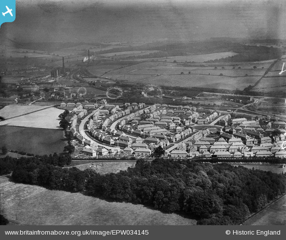
EPW034145 ENGLAND (1930). The Bulwell Hall Estate, Bulwell, from the south-west, 1930
© Copyright OpenStreetMap contributors and licensed by the OpenStreetMap Foundation. 2026. Cartography is licensed as CC BY-SA.
Nearby Images (15)
Details
| Title | [EPW034145] The Bulwell Hall Estate, Bulwell, from the south-west, 1930 |
| Reference | EPW034145 |
| Date | July-1930 |
| Link | |
| Place name | BULWELL |
| Parish | |
| District | |
| Country | ENGLAND |
| Easting / Northing | 454137, 346696 |
| Longitude / Latitude | -1.192958149897, 53.014520028208 |
| National Grid Reference | SK541467 |


![[EPW034145] The Bulwell Hall Estate, Bulwell, from the south-west, 1930](http://britainfromabove.org.uk/sites/all/libraries/aerofilms-images/public/100x100/EPW/034/EPW034145.jpg)
![[EPW020741] The site of the Bulwell Hall Estate, Bulwell, 1928](http://britainfromabove.org.uk/sites/all/libraries/aerofilms-images/public/100x100/EPW/020/EPW020741.jpg)
![[EAW038724] Grindon Crescent and Bulwell Hall Park, Bulwell, 1951. This image has been produced from a print.](http://britainfromabove.org.uk/sites/all/libraries/aerofilms-images/public/100x100/EAW/038/EAW038724.jpg)
![[EPW034144] The Bulwell Hall Estate, Bulwell, 1930](http://britainfromabove.org.uk/sites/all/libraries/aerofilms-images/public/100x100/EPW/034/EPW034144.jpg)
![[EPW034148] The Bulwell Hall Estate, Bulwell, 1930](http://britainfromabove.org.uk/sites/all/libraries/aerofilms-images/public/100x100/EPW/034/EPW034148.jpg)
![[EPW034147] The Bulwell Hall Estate, Bulwell, 1930](http://britainfromabove.org.uk/sites/all/libraries/aerofilms-images/public/100x100/EPW/034/EPW034147.jpg)
![[EPW020742] The site of the Bulwell Hall Estate, Bulwell, 1928](http://britainfromabove.org.uk/sites/all/libraries/aerofilms-images/public/100x100/EPW/020/EPW020742.jpg)
![[EPW020737] The site of the Bulwell Hall Estate, Bulwell, 1928](http://britainfromabove.org.uk/sites/all/libraries/aerofilms-images/public/100x100/EPW/020/EPW020737.jpg)
![[EPW020743] The site of the Bulwell Hall Estate, Bulwell, 1928](http://britainfromabove.org.uk/sites/all/libraries/aerofilms-images/public/100x100/EPW/020/EPW020743.jpg)
![[EPW034135] The Bulwell Hall Estate, Bulwell, from the south-west, 1930](http://britainfromabove.org.uk/sites/all/libraries/aerofilms-images/public/100x100/EPW/034/EPW034135.jpg)
![[EPW034146] The Bulwell Hall Estate, Bulwell, 1930. This image has been produced from a copy-negative.](http://britainfromabove.org.uk/sites/all/libraries/aerofilms-images/public/100x100/EPW/034/EPW034146.jpg)
![[EPW034137] The Bulwell Hall Estate, Bulwell, 1930](http://britainfromabove.org.uk/sites/all/libraries/aerofilms-images/public/100x100/EPW/034/EPW034137.jpg)
![[EPW034139] The Bulwell Hall Estate, Bulwell, 1930](http://britainfromabove.org.uk/sites/all/libraries/aerofilms-images/public/100x100/EPW/034/EPW034139.jpg)
![[EPW020740] The site of the Bulwell Hall Estate, Bulwell, 1928](http://britainfromabove.org.uk/sites/all/libraries/aerofilms-images/public/100x100/EPW/020/EPW020740.jpg)
![[EPW034149] The Bulwell Hall Estate, Bulwell, 1930](http://britainfromabove.org.uk/sites/all/libraries/aerofilms-images/public/100x100/EPW/034/EPW034149.jpg)
