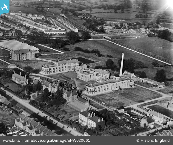
EPW020061 ENGLAND (1927). Redhill County Hospital, Burnt Oak, 1927
© Copyright OpenStreetMap contributors and licensed by the OpenStreetMap Foundation. 2026. Cartography is licensed as CC BY-SA.
Nearby Images (26)
Details
| Title | [EPW020061] Redhill County Hospital, Burnt Oak, 1927 |
| Reference | EPW020061 |
| Date | 4-November-1927 |
| Link | |
| Place name | BURNT OAK |
| Parish | |
| District | |
| Country | ENGLAND |
| Easting / Northing | 519809, 191086 |
| Longitude / Latitude | -0.26974374706769, 51.605377389646 |
| National Grid Reference | TQ198911 |
Pins
Be the first to add a comment to this image!
User Comment Contributions
Before North, South and East Roads were laid out from about 1867 onwards, Burnt Oak did not exist as a district; the area was known as Redhill and that name was originally given to Edgware General Hospital. On this picture Redhill Lodge can be seen standing in front of the new hospital buildings. Built I believe around 1860, Redhill Lodge was originally a school, later became an old men's home and was finally a shelter for homeless families. If any one can add to or indeed correct my information I would be interested to hear from you. |

colsouth111 |
Saturday 1st of June 2013 03:24:27 PM |


![[EPW020061] Redhill County Hospital, Burnt Oak, 1927](http://britainfromabove.org.uk/sites/all/libraries/aerofilms-images/public/100x100/EPW/020/EPW020061.jpg)
![[EAW028467] The Edgware General Hospital and the surrounding residential area, Burnt Oak, 1950](http://britainfromabove.org.uk/sites/all/libraries/aerofilms-images/public/100x100/EAW/028/EAW028467.jpg)
![[EAW028461] The Edgware General Hospital and the surrounding residential area, Burnt Oak, 1950](http://britainfromabove.org.uk/sites/all/libraries/aerofilms-images/public/100x100/EAW/028/EAW028461.jpg)
![[EPW015981] The Redhill County Hospital under construction and the Musical Instrument Works, Burnt Oak, 1926](http://britainfromabove.org.uk/sites/all/libraries/aerofilms-images/public/100x100/EPW/015/EPW015981.jpg)
![[EPW020058] Redhill County Hospital, Burnt Oak, 1927](http://britainfromabove.org.uk/sites/all/libraries/aerofilms-images/public/100x100/EPW/020/EPW020058.jpg)
![[EPW020059] Redhill County Hospital and Musical Instrument Works, Burnt Oak, 1927](http://britainfromabove.org.uk/sites/all/libraries/aerofilms-images/public/100x100/EPW/020/EPW020059.jpg)
![[EPW020060] Redhill County Hospital and Musical Instrument Works, Burnt Oak, 1927](http://britainfromabove.org.uk/sites/all/libraries/aerofilms-images/public/100x100/EPW/020/EPW020060.jpg)
![[EPW001354] The Union Schools, Burnt Oak, 1920](http://britainfromabove.org.uk/sites/all/libraries/aerofilms-images/public/100x100/EPW/001/EPW001354.jpg)
![[EAW028463] The Edgware General Hospital and the surrounding residential area, Burnt Oak, 1950](http://britainfromabove.org.uk/sites/all/libraries/aerofilms-images/public/100x100/EAW/028/EAW028463.jpg)
![[EPW020054] Redhill County Hospital, Burnt Oak, 1927](http://britainfromabove.org.uk/sites/all/libraries/aerofilms-images/public/100x100/EPW/020/EPW020054.jpg)
![[EPW020057] Redhill County Hospital and Musical Instrument Works, Burnt Oak, 1927](http://britainfromabove.org.uk/sites/all/libraries/aerofilms-images/public/100x100/EPW/020/EPW020057.jpg)
![[EPW020056] Redhill County Hospital and High Road, Burnt Oak, 1927](http://britainfromabove.org.uk/sites/all/libraries/aerofilms-images/public/100x100/EPW/020/EPW020056.jpg)
![[EAW028459] The Edgware General Hospital and the surrounding residential area, Burnt Oak, 1950](http://britainfromabove.org.uk/sites/all/libraries/aerofilms-images/public/100x100/EAW/028/EAW028459.jpg)
![[EPW020055] Redhill County Hospital, Burnt Oak, 1927](http://britainfromabove.org.uk/sites/all/libraries/aerofilms-images/public/100x100/EPW/020/EPW020055.jpg)
![[EAW028466] The Edgware General Hospital and the surrounding residential area, Burnt Oak, 1950](http://britainfromabove.org.uk/sites/all/libraries/aerofilms-images/public/100x100/EAW/028/EAW028466.jpg)
![[EPW020062] Redhill County Hospital, Burnt Oak, 1927](http://britainfromabove.org.uk/sites/all/libraries/aerofilms-images/public/100x100/EPW/020/EPW020062.jpg)
![[EPW001355] The High Road, Burnt Oak, 1920](http://britainfromabove.org.uk/sites/all/libraries/aerofilms-images/public/100x100/EPW/001/EPW001355.jpg)
![[EAW028460] The Edgware General Hospital and the surrounding residential area, Burnt Oak, 1950](http://britainfromabove.org.uk/sites/all/libraries/aerofilms-images/public/100x100/EAW/028/EAW028460.jpg)
![[EAW028465] The Edgware General Hospital and the surrounding residential area, Burnt Oak, 1950](http://britainfromabove.org.uk/sites/all/libraries/aerofilms-images/public/100x100/EAW/028/EAW028465.jpg)
![[EPW016825] The Hawkes and Co. Musical Instrument Works, Burnt Oak, 1926](http://britainfromabove.org.uk/sites/all/libraries/aerofilms-images/public/100x100/EPW/016/EPW016825.jpg)
![[EPW016826] The Hawkes and Co. Musical Instrument Works, Burnt Oak, 1926](http://britainfromabove.org.uk/sites/all/libraries/aerofilms-images/public/100x100/EPW/016/EPW016826.jpg)
![[EAW028462] The Edgware General Hospital and the surrounding residential area, Burnt Oak, 1950](http://britainfromabove.org.uk/sites/all/libraries/aerofilms-images/public/100x100/EAW/028/EAW028462.jpg)
![[EAW028464] The Edgware General Hospital and the surrounding residential area, Burnt Oak, 1950](http://britainfromabove.org.uk/sites/all/libraries/aerofilms-images/public/100x100/EAW/028/EAW028464.jpg)
![[EPW015339] Redhill County Hospital under construction, Burnt Oak, 1926](http://britainfromabove.org.uk/sites/all/libraries/aerofilms-images/public/100x100/EPW/015/EPW015339.jpg)
![[EPW016827] The Hawkes and Co. Musical Instrument Works, Burnt Oak, 1926](http://britainfromabove.org.uk/sites/all/libraries/aerofilms-images/public/100x100/EPW/016/EPW016827.jpg)
![[EPW001352] North Road, South Road and East Road, Burnt Oak, 1920](http://britainfromabove.org.uk/sites/all/libraries/aerofilms-images/public/100x100/EPW/001/EPW001352.jpg)
