
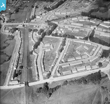
EPW019335 ENGLAND (1927). New housing next to the London Aerodrome, Burnt Oak, 1927

© Copyright OpenStreetMap contributors and licensed by the OpenStreetMap Foundation. 2026. Cartography is licensed as CC BY-SA.
Nearby Images (10)
EPW019335

EPW017586

EPW016518

EPW031550

EPW019336

EPW035548

EPW019311

EPW019338

EPW034858

EPW019337

Details
| Title | [EPW019335] New housing next to the London Aerodrome, Burnt Oak, 1927 |
| Reference | EPW019335 |
| Date | 23-September-1927 |
| Link | |
| Place name | BURNT OAK |
| Parish | |
| District | |
| Country | ENGLAND |
| Easting / Northing | 520669, 190696 |
| Longitude / Latitude | -0.25746419603795, 51.601688332523 |
| National Grid Reference | TQ207907 |
Pins

bazouteast |
Thursday 15th of October 2020 11:17:17 PM | |
|
John Wass |
Wednesday 23rd of July 2014 07:50:42 PM | |
|
snapper31 |
Monday 7th of January 2013 02:54:39 PM | |
|
snapper31 |
Monday 7th of January 2013 02:51:40 PM | |
|
snapper31 |
Monday 7th of January 2013 02:50:51 PM | |
|
snapper31 |
Monday 7th of January 2013 02:48:09 PM | |
|
snapper31 |
Monday 7th of January 2013 02:44:12 PM | |

Class31 |
Thursday 23rd of August 2012 10:44:58 PM | |
|
Class31 |
Thursday 23rd of August 2012 10:44:29 PM | |
Montrose Avenue crossed the Tube lines and took the 2nd road left. If it was changed after 1927 I apologise. |
snapper31 |
Monday 7th of January 2013 02:53:28 PM |
|
Class31 |
Thursday 23rd of August 2012 10:44:05 PM |
User Comment Contributions
Railway and environs |
peterb |
Friday 2nd of November 2012 08:35:45 PM |