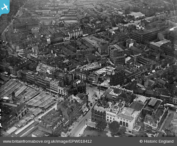
EPW018412 ENGLAND (1927). The city by the junction of Gallowtree Gate and Horsefair Street, Leicester, 1927. This image has been produced from a copy-negative.
© Copyright OpenStreetMap contributors and licensed by the OpenStreetMap Foundation. 2026. Cartography is licensed as CC BY-SA.
Nearby Images (29)
Details
| Title | [EPW018412] The city by the junction of Gallowtree Gate and Horsefair Street, Leicester, 1927. This image has been produced from a copy-negative. |
| Reference | EPW018412 |
| Date | 10-June-1927 |
| Link | |
| Place name | LEICESTER |
| Parish | |
| District | |
| Country | ENGLAND |
| Easting / Northing | 458863, 304498 |
| Longitude / Latitude | -1.1301237418531, 52.634684839407 |
| National Grid Reference | SK589045 |
Pins
Be the first to add a comment to this image!


![[EPW018412] The city by the junction of Gallowtree Gate and Horsefair Street, Leicester, 1927. This image has been produced from a copy-negative.](http://britainfromabove.org.uk/sites/all/libraries/aerofilms-images/public/100x100/EPW/018/EPW018412.jpg)
![[EAW051834] The city centre around High Street and Humberstone Gate, Leicester, 1953](http://britainfromabove.org.uk/sites/all/libraries/aerofilms-images/public/100x100/EAW/051/EAW051834.jpg)
![[EPW018422] Gallowtree Gate and environs, Leicester, 1927. This image has been produced from a print.](http://britainfromabove.org.uk/sites/all/libraries/aerofilms-images/public/100x100/EPW/018/EPW018422.jpg)
![[EPW018431] The junction of Gallowtree Gate and Halford Street, Leicester, 1927](http://britainfromabove.org.uk/sites/all/libraries/aerofilms-images/public/100x100/EPW/018/EPW018431.jpg)
![[EAW024240] Charles Street, Granby Street and the city centre, Leicester, 1949](http://britainfromabove.org.uk/sites/all/libraries/aerofilms-images/public/100x100/EAW/024/EAW024240.jpg)
![[EPW018436] Town Hall Square and environs, Leicester, 1927](http://britainfromabove.org.uk/sites/all/libraries/aerofilms-images/public/100x100/EPW/018/EPW018436.jpg)
![[EPW055011] Charles Street and the city centre, Leicester, 1937](http://britainfromabove.org.uk/sites/all/libraries/aerofilms-images/public/100x100/EPW/055/EPW055011.jpg)
![[EAW024242] Gallowtree Gate, Cheapside and the city centre, Leicester, 1949](http://britainfromabove.org.uk/sites/all/libraries/aerofilms-images/public/100x100/EAW/024/EAW024242.jpg)
![[EAW024244] Charles Street and the city centre, Leicester, 1949](http://britainfromabove.org.uk/sites/all/libraries/aerofilms-images/public/100x100/EAW/024/EAW024244.jpg)
![[EPW020892] The Town Square and city centre, Leicester, 1928](http://britainfromabove.org.uk/sites/all/libraries/aerofilms-images/public/100x100/EPW/020/EPW020892.jpg)
![[EAW024239] Humberstone Gate, Charles Street and the city centre, Leicester, 1949](http://britainfromabove.org.uk/sites/all/libraries/aerofilms-images/public/100x100/EAW/024/EAW024239.jpg)
![[EPW018421] The Town Hall, Horsefair Street and environs, Leicester, 1927. This image has been produced from a print.](http://britainfromabove.org.uk/sites/all/libraries/aerofilms-images/public/100x100/EPW/018/EPW018421.jpg)
![[EAW024243] The Clock Tower, Humberstone Gate and the city centre, Leicester, 1949](http://britainfromabove.org.uk/sites/all/libraries/aerofilms-images/public/100x100/EAW/024/EAW024243.jpg)
![[EPW047643] The Clock Tower and the city centre, Leicester, 1935](http://britainfromabove.org.uk/sites/all/libraries/aerofilms-images/public/100x100/EPW/047/EPW047643.jpg)
![[EPW018433] East Gates and environs, Leicester, 1927](http://britainfromabove.org.uk/sites/all/libraries/aerofilms-images/public/100x100/EPW/018/EPW018433.jpg)
![[EPW047645] The city centre, Leicester, 1935](http://britainfromabove.org.uk/sites/all/libraries/aerofilms-images/public/100x100/EPW/047/EPW047645.jpg)
![[EPW020895] The city centre, Leicester, 1928](http://britainfromabove.org.uk/sites/all/libraries/aerofilms-images/public/100x100/EPW/020/EPW020895.jpg)
![[EPW047641] The Haymarket and city centre, Leicester, 1935](http://britainfromabove.org.uk/sites/all/libraries/aerofilms-images/public/100x100/EPW/047/EPW047641.jpg)
![[EPW047868] Bishop Street and environs, Leicester, 1935](http://britainfromabove.org.uk/sites/all/libraries/aerofilms-images/public/100x100/EPW/047/EPW047868.jpg)
![[EPW055006] The Haymarket and the city centre, Leicester, 1937](http://britainfromabove.org.uk/sites/all/libraries/aerofilms-images/public/100x100/EPW/055/EPW055006.jpg)
![[EPW061213] Charles Street and environs, Leicester, 1939](http://britainfromabove.org.uk/sites/all/libraries/aerofilms-images/public/100x100/EPW/061/EPW061213.jpg)
![[EPW055002] The city around Belvoir Street and Granby Street, Leicester, 1937](http://britainfromabove.org.uk/sites/all/libraries/aerofilms-images/public/100x100/EPW/055/EPW055002.jpg)
![[EPW055009] Charles Street, St George's Church and the city, Leicester, 1937](http://britainfromabove.org.uk/sites/all/libraries/aerofilms-images/public/100x100/EPW/055/EPW055009.jpg)
![[EAW051831] The city centre around Lee Street and Humberstone Gate, Leicester, 1953](http://britainfromabove.org.uk/sites/all/libraries/aerofilms-images/public/100x100/EAW/051/EAW051831.jpg)
![[EPW061211] The city centre, Leicester, 1939](http://britainfromabove.org.uk/sites/all/libraries/aerofilms-images/public/100x100/EPW/061/EPW061211.jpg)
![[EAW052680] Arthur Foister and Sons Ltd (Cherub Ltd) Factory on Charles Street, Leicester, 1953. This image was marked by Aerofilms Ltd for photo editing.](http://britainfromabove.org.uk/sites/all/libraries/aerofilms-images/public/100x100/EAW/052/EAW052680.jpg)
![[EAW052674] Arthur Foister & Sons Ltd (Cherub Ltd) Factory on Charles Street, St George's Church and Rutland Street, Leicester, 1953. This image was marked by Aerofilms Ltd for photo editing.](http://britainfromabove.org.uk/sites/all/libraries/aerofilms-images/public/100x100/EAW/052/EAW052674.jpg)
![[EAW052676] Arthur Foister & Sons Ltd (Cherub Ltd) Factory on Charles Street and St George's Church, Leicester, 1953. This image was marked by Aerofilms Ltd for photo editing.](http://britainfromabove.org.uk/sites/all/libraries/aerofilms-images/public/100x100/EAW/052/EAW052676.jpg)
![[EPW055010] The city centre, Leicester, from the south-west, 1937](http://britainfromabove.org.uk/sites/all/libraries/aerofilms-images/public/100x100/EPW/055/EPW055010.jpg)