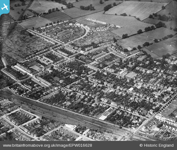
EPW016628 ENGLAND (1926). Elm Road and environs, New Malden, 1926
© Copyright OpenStreetMap contributors and licensed by the OpenStreetMap Foundation. 2026. Cartography is licensed as CC BY-SA.
Details
| Title | [EPW016628] Elm Road and environs, New Malden, 1926 |
| Reference | EPW016628 |
| Date | August-1926 |
| Link | |
| Place name | NEW MALDEN |
| Parish | |
| District | |
| Country | ENGLAND |
| Easting / Northing | 520897, 168801 |
| Longitude / Latitude | -0.26167957045085, 51.404839685304 |
| National Grid Reference | TQ209688 |
Pins

New Malden |
Thursday 2nd of February 2017 02:55:14 PM | |

New Malden |
Thursday 2nd of February 2017 02:53:31 PM | |

New Malden |
Thursday 2nd of February 2017 02:51:08 PM | |

John Wass |
Sunday 24th of May 2015 04:28:02 PM | |

John Wass |
Thursday 26th of March 2015 02:51:17 PM | |

@JohnSouthsea |
Thursday 20th of February 2014 02:01:21 PM | |
 8-2007.JPG)
Keith |
Thursday 5th of July 2012 12:51:05 AM |


![[EPW016628] Elm Road and environs, New Malden, 1926](http://britainfromabove.org.uk/sites/all/libraries/aerofilms-images/public/100x100/EPW/016/EPW016628.jpg)
![[EPW016632] The Crescent and Mount Pleasant Road, New Malden, 1926](http://britainfromabove.org.uk/sites/all/libraries/aerofilms-images/public/100x100/EPW/016/EPW016632.jpg)
![[EPW017153] The Crescent and environs, New Malden, 1926](http://britainfromabove.org.uk/sites/all/libraries/aerofilms-images/public/100x100/EPW/017/EPW017153.jpg)
![[EPW016626] Lime Grove and environs, New Malden, 1926](http://britainfromabove.org.uk/sites/all/libraries/aerofilms-images/public/100x100/EPW/016/EPW016626.jpg)