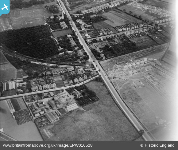
EPW016528 ENGLAND (1926). Bath Road and Hounslow West Station, Hounslow, 1926
    © Copyright OpenStreetMap contributors and licensed by the OpenStreetMap Foundation. 2025. Cartography is licensed as CC BY-SA.
  
Nearby Images (19)
Details
| Title | [EPW016528] Bath Road and Hounslow West Station, Hounslow, 1926 | 
| Reference | EPW016528 | 
| Date | August-1926 | 
| Link | |
| Place name | HOUNSLOW | 
| Parish | |
| District | |
| Country | ENGLAND | 
| Easting / Northing | 512189, 176153 | 
| Longitude / Latitude | -0.38450197356606, 51.472716812845 | 
| National Grid Reference | TQ122762 | 
Pins
|  Vicarage Farm |   surreyman | Tuesday 2nd of January 2018 11:34:55 AM | 
|  Hounslow Cricket Club, Church Meadow. |   Ian Taylor | Monday 7th of August 2017 02:49:52 PM | 
|  District Railway 6-car electic train at original Hounslow West station (formerly Hounslow Barracks station) |   Isleworth1961 | Tuesday 17th of July 2012 02:18:27 PM | 
 
             
  ![[EPW016528] Bath Road and Hounslow West Station, Hounslow, 1926](http://britainfromabove.org.uk/sites/all/libraries/aerofilms-images/public/100x100/EPW/016/EPW016528.jpg) 
  
                                          ![[EPW037296] Hounslow West Station, Bath Road and environs, Hounslow West, 1932. This image has been produced from a copy-negative.](http://britainfromabove.org.uk/sites/all/libraries/aerofilms-images/public/100x100/EPW/037/EPW037296.jpg) 
 ![[EPW016527] Bath Road, Hounslow, 1926](http://britainfromabove.org.uk/sites/all/libraries/aerofilms-images/public/100x100/EPW/016/EPW016527.jpg) 
 ![[EPW037518] "The Earl Haigh" public house opposite Hounslow West Station, Hounslow, 1932](http://britainfromabove.org.uk/sites/all/libraries/aerofilms-images/public/100x100/EPW/037/EPW037518.jpg) 
 ![[EPW037517] "The Earl Haigh" public house opposite Hounslow West Station, Hounslow, 1932](http://britainfromabove.org.uk/sites/all/libraries/aerofilms-images/public/100x100/EPW/037/EPW037517.jpg) 
 ![[EPW037334] The Earl Haig Pub off Bath Road, Hounslow West, 1932. This image has been produced from a copy-negative.](http://britainfromabove.org.uk/sites/all/libraries/aerofilms-images/public/100x100/EPW/037/EPW037334.jpg) 
 ![[EPW037519] "The Earl Haigh" public house opposite Hounslow West Station, Hounslow, 1932](http://britainfromabove.org.uk/sites/all/libraries/aerofilms-images/public/100x100/EPW/037/EPW037519.jpg) 
 ![[EPW016529] Bath Road and Hounslow West Station, Hounslow, 1926](http://britainfromabove.org.uk/sites/all/libraries/aerofilms-images/public/100x100/EPW/016/EPW016529.jpg) 
 ![[EPW035079] Vicarage Farm, Hounslow West Station and environs, Hounslow West, 1931](http://britainfromabove.org.uk/sites/all/libraries/aerofilms-images/public/100x100/EPW/035/EPW035079.jpg) 
 ![[EPW033774] Houses and St Paul's Church with Heston Air Park in the distance, Hounslow West, from the south-east, 1930. This image has been produced from a damaged negative](http://britainfromabove.org.uk/sites/all/libraries/aerofilms-images/public/100x100/EPW/033/EPW033774.jpg) 
 ![[EPW037332] Houses and gardens opposite Hounslow West Station, Hounslow, 1932](http://britainfromabove.org.uk/sites/all/libraries/aerofilms-images/public/100x100/EPW/037/EPW037332.jpg) 
 ![[EPW017168] New Housing at Francis Road, Hounslow, 1926](http://britainfromabove.org.uk/sites/all/libraries/aerofilms-images/public/100x100/EPW/017/EPW017168.jpg) 
 ![[EPW017162] New housing at Francis Road, Hounslow, 1926](http://britainfromabove.org.uk/sites/all/libraries/aerofilms-images/public/100x100/EPW/017/EPW017162.jpg) 
 ![[EPW033773] Heston Air Park and environs, Heston, from the south-east, 1930](http://britainfromabove.org.uk/sites/all/libraries/aerofilms-images/public/100x100/EPW/033/EPW033773.jpg) 
 ![[EPW033772] Heston Air Park and environs, Heston, from the south-east, 1930](http://britainfromabove.org.uk/sites/all/libraries/aerofilms-images/public/100x100/EPW/033/EPW033772.jpg) 
 ![[EPW035093] Residential development around Hounslow West Station, Hounslow West, 1931](http://britainfromabove.org.uk/sites/all/libraries/aerofilms-images/public/100x100/EPW/035/EPW035093.jpg) 
 ![[EPW037294] Looking over Heston, Hounslow West, from the south, 1932. This image has been produced from a copy-negative.](http://britainfromabove.org.uk/sites/all/libraries/aerofilms-images/public/100x100/EPW/037/EPW037294.jpg) 
 ![[EPW035080] Vicarage Farm, Hounslow West Station and the Great West Road, Hounslow West, 1931](http://britainfromabove.org.uk/sites/all/libraries/aerofilms-images/public/100x100/EPW/035/EPW035080.jpg) 
 ![[EPW035032] The Metropolitan and District Line and Hounslow, Heston, from the north-west, 1931](http://britainfromabove.org.uk/sites/all/libraries/aerofilms-images/public/100x100/EPW/035/EPW035032.jpg)