
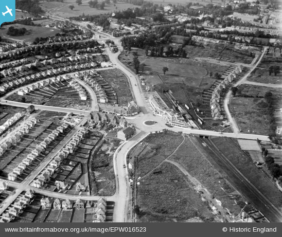
EPW016523 ENGLAND (1926). Central Circus and environs, Hendon, 1926
© Copyright OpenStreetMap contributors and licensed by the OpenStreetMap Foundation. 2026. Cartography is licensed as CC BY-SA.
Nearby Images (15)
EPW016523

EPW008746

EPW016521

EPW038717

EPW031659

EPW016638

EPW009348

EPW031656

EPW016520

EPR000516

EPW009537

EPW040430

EPW031652

EPW016522

EPW031654

Details
| Title | [EPW016523] Central Circus and environs, Hendon, 1926 |
| Reference | EPW016523 |
| Date | August-1926 |
| Link | |
| Place name | HENDON |
| Parish | |
| District | |
| Country | ENGLAND |
| Easting / Northing | 522902, 188620 |
| Longitude / Latitude | -0.22596199906841, 51.582546187165 |
| National Grid Reference | TQ229886 |
Pins

Wordsmith52 |
Saturday 31st of August 2013 04:48:30 PM | |
|
Wordsmith52 |
Saturday 31st of August 2013 04:46:42 PM | |
|
Wordsmith52 |
Saturday 31st of August 2013 04:45:22 PM | |
|
Wordsmith52 |
Saturday 31st of August 2013 04:43:43 PM | |
|
Jim Rea |
Monday 27th of August 2012 02:51:15 PM | |
Colindeep Lane was often used as a route into London - especially to avoid the often flooded and marshy tracts around what is now Staples Corner near the River Brent. Cardinal Wolsey was said to have used this route in the early 16th century on his many visits to London. |
Wordsmith52 |
Friday 30th of August 2013 11:03:49 PM |
|
Jim Rea |
Monday 27th of August 2012 02:44:27 PM | |
|
Jim Rea |
Monday 27th of August 2012 02:40:48 PM | |
|
Jim Rea |
Monday 27th of August 2012 02:34:35 PM | |
|
JC |
Saturday 21st of July 2012 12:04:54 AM | |
This is a correct statement, this was the original location, moved to widen and reconstruct the carrigeway in and around the Burroughs Hendon. The new Ware Memorial site is just south of the remains of Burrough's Paond |
Jim Rea |
Monday 27th of August 2012 02:37:49 PM |
|
JC |
Saturday 21st of July 2012 12:03:53 AM | |
|
JC |
Saturday 21st of July 2012 12:00:14 AM | |
|
JC |
Friday 20th of July 2012 11:57:01 PM | |
|
JC |
Friday 20th of July 2012 11:54:45 PM | |
|
JC |
Friday 20th of July 2012 11:52:25 PM | |
|
JC |
Friday 20th of July 2012 11:50:40 PM | |
|
JC |
Friday 20th of July 2012 11:50:03 PM | |
Grove House has lng gone, but the remains of the Gardens are behind the Town Hall, with some original footpaths, a sunken lawn area and a few steps. Some of the fine original ornamental trees remain. |
Jim Rea |
Monday 27th of August 2012 02:47:19 PM |
|
JC |
Friday 20th of July 2012 11:49:02 PM | |
|
JC |
Friday 20th of July 2012 11:48:20 PM | |
|
JC |
Friday 20th of July 2012 11:47:21 PM | |
|
JC |
Friday 20th of July 2012 11:44:47 PM | |
|
JC |
Friday 20th of July 2012 11:44:06 PM | |
The residential roads surrounding Vivian Ave (Foscote Rd, Allington rd, Crespigny Rd, Neeld Crescent etc) were laid out just before the First World War and construction of houses was thus held up due to the conflict. Most of the roads were therefore empty for some years and houses were built in the 1920s and 1930s. If you look carefully on the kerbside drain covers you will see the old "HUDC" (Hendon Urban District Council)initials (i.e. pre-1932) and in some cases a date - 1912 and 1913. This was when the gratings were produced and they must have been installed soon afterwards. These large detached houses were (and in some cases still are) quite imposing, but the area has deteriorated somewhat over the last 40 years or so with the passage of time. This seems to be the case with most of suburbia everywhere however. |
Wordsmith52 |
Friday 30th of August 2013 11:43:53 PM |
|
JC |
Friday 20th of July 2012 11:40:35 PM |
User Comment Contributions
Allington Road |
Wordsmith52 |
Saturday 31st of August 2013 04:44:29 PM |