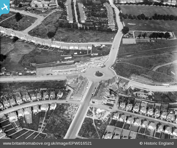
EPW016521 ENGLAND (1926). Central Circus and environs, Hendon, 1926
© Copyright OpenStreetMap contributors and licensed by the OpenStreetMap Foundation. 2026. Cartography is licensed as CC BY-SA.
Nearby Images (16)
Details
| Title | [EPW016521] Central Circus and environs, Hendon, 1926 |
| Reference | EPW016521 |
| Date | August-1926 |
| Link | |
| Place name | HENDON |
| Parish | |
| District | |
| Country | ENGLAND |
| Easting / Northing | 522937, 188618 |
| Longitude / Latitude | -0.22545775020833, 51.5825205759 |
| National Grid Reference | TQ229886 |
Pins
Be the first to add a comment to this image!


![[EPW016521] Central Circus and environs, Hendon, 1926](http://britainfromabove.org.uk/sites/all/libraries/aerofilms-images/public/100x100/EPW/016/EPW016521.jpg)
![[EPW008746] Construction of Hendon Central Station and the Central Circus, Hendon, 1923. This image has been produced from a copy-negative.](http://britainfromabove.org.uk/sites/all/libraries/aerofilms-images/public/100x100/EPW/008/EPW008746.jpg)
![[EPW031659] Central Circus, Hendon, 1930](http://britainfromabove.org.uk/sites/all/libraries/aerofilms-images/public/100x100/EPW/031/EPW031659.jpg)
![[EPW016523] Central Circus and environs, Hendon, 1926](http://britainfromabove.org.uk/sites/all/libraries/aerofilms-images/public/100x100/EPW/016/EPW016523.jpg)
![[EPW038717] Hendon Central Station and the Central Circus, Hendon, 1932](http://britainfromabove.org.uk/sites/all/libraries/aerofilms-images/public/100x100/EPW/038/EPW038717.jpg)
![[EPW009348] The Central Circus under construction, Hendon, 1923. This image has been produced from a print.](http://britainfromabove.org.uk/sites/all/libraries/aerofilms-images/public/100x100/EPW/009/EPW009348.jpg)
![[EPW016638] Central Circus and environs, Hendon, 1926](http://britainfromabove.org.uk/sites/all/libraries/aerofilms-images/public/100x100/EPW/016/EPW016638.jpg)
![[EPW031652] Hendon Central Railway Station and Central Circus, Hendon, 1930](http://britainfromabove.org.uk/sites/all/libraries/aerofilms-images/public/100x100/EPW/031/EPW031652.jpg)
![[EPW016520] Central Circus and environs, Hendon, 1926](http://britainfromabove.org.uk/sites/all/libraries/aerofilms-images/public/100x100/EPW/016/EPW016520.jpg)
![[EPW009537] The Central Circus under construction, Hendon, 1923. This image has been produced from a copy-negative.](http://britainfromabove.org.uk/sites/all/libraries/aerofilms-images/public/100x100/EPW/009/EPW009537.jpg)
![[EPW031656] Central Circus and Queen's Road, Hendon, from the west, 1930](http://britainfromabove.org.uk/sites/all/libraries/aerofilms-images/public/100x100/EPW/031/EPW031656.jpg)
![[EPR000516] Central Circus, Hendon, 1935](http://britainfromabove.org.uk/sites/all/libraries/aerofilms-images/public/100x100/EPR/000/EPR000516.jpg)
![[EPW040430] Housing development around Hendon Central, Hendon, from the south, 1932](http://britainfromabove.org.uk/sites/all/libraries/aerofilms-images/public/100x100/EPW/040/EPW040430.jpg)
![[EPW016522] Central Circus and Vivian Avenue, Hendon, 1926](http://britainfromabove.org.uk/sites/all/libraries/aerofilms-images/public/100x100/EPW/016/EPW016522.jpg)
![[EPW031654] Watford Way and Central Circus, Hendon, from the north, 1930](http://britainfromabove.org.uk/sites/all/libraries/aerofilms-images/public/100x100/EPW/031/EPW031654.jpg)
![[EPW040432] Housing development around Hendon Central, Hendon, from the south, 1932](http://britainfromabove.org.uk/sites/all/libraries/aerofilms-images/public/100x100/EPW/040/EPW040432.jpg)