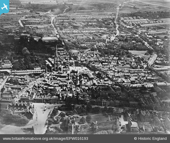
EPW016193 ENGLAND (1926). The town centre, Newark-on-Trent, from the north-west, 1926. This image has been produced from a copy-negative.
© Copyright OpenStreetMap contributors and licensed by the OpenStreetMap Foundation. 2026. Cartography is licensed as CC BY-SA.
Nearby Images (24)
Details
| Title | [EPW016193] The town centre, Newark-on-Trent, from the north-west, 1926. This image has been produced from a copy-negative. |
| Reference | EPW016193 |
| Date | July-1926 |
| Link | |
| Place name | NEWARK-ON-TRENT |
| Parish | NEWARK |
| District | |
| Country | ENGLAND |
| Easting / Northing | 479694, 354007 |
| Longitude / Latitude | -0.81023667154597, 53.077037856215 |
| National Grid Reference | SK797540 |
Pins
Be the first to add a comment to this image!


![[EPW016193] The town centre, Newark-on-Trent, from the north-west, 1926. This image has been produced from a copy-negative.](http://britainfromabove.org.uk/sites/all/libraries/aerofilms-images/public/100x100/EPW/016/EPW016193.jpg)
![[EAW013672] The castle, Newark-on-Trent, 1948. This image has been affected by flare.](http://britainfromabove.org.uk/sites/all/libraries/aerofilms-images/public/100x100/EAW/013/EAW013672.jpg)
![[EAW006308] Newark Castle, Newark-on-Trent, 1947. This image has been produced from a print.](http://britainfromabove.org.uk/sites/all/libraries/aerofilms-images/public/100x100/EAW/006/EAW006308.jpg)
![[EAW006306] Newark Castle, Castle Gate and environs, Newark-on-Trent, 1947](http://britainfromabove.org.uk/sites/all/libraries/aerofilms-images/public/100x100/EAW/006/EAW006306.jpg)
![[EPW015267] The Castle and Trent Bridge, Newark-on-Trent, 1926](http://britainfromabove.org.uk/sites/all/libraries/aerofilms-images/public/100x100/EPW/015/EPW015267.jpg)
![[EAW006307] Newark Castle, Beast Market Hill and the town, Newark-on-Trent, 1947](http://britainfromabove.org.uk/sites/all/libraries/aerofilms-images/public/100x100/EAW/006/EAW006307.jpg)
![[EAW013673] The castle, Newark-on-Trent, 1948. This image has been affected by flare.](http://britainfromabove.org.uk/sites/all/libraries/aerofilms-images/public/100x100/EAW/013/EAW013673.jpg)
![[EAW016512] Newark Castle, the River Trent and the town, Newark-on-Trent, from the north-east, 1948. This image has been produced from a print.](http://britainfromabove.org.uk/sites/all/libraries/aerofilms-images/public/100x100/EAW/016/EAW016512.jpg)
![[EAW006304] Newark Castle, Newark-on-Trent, 1947. This image has been produced from a print.](http://britainfromabove.org.uk/sites/all/libraries/aerofilms-images/public/100x100/EAW/006/EAW006304.jpg)
![[EAW016510] Newark Castle, Beast Market Hill and the town, Newark-on-Trent, 1948. This image has been produced from a print.](http://britainfromabove.org.uk/sites/all/libraries/aerofilms-images/public/100x100/EAW/016/EAW016510.jpg)
![[EAW006303] Newark Castle, Newark-on-Trent, 1947. This image has been produced from a print.](http://britainfromabove.org.uk/sites/all/libraries/aerofilms-images/public/100x100/EAW/006/EAW006303.jpg)
![[EAW016508] Newark Castle and Castle Gardens, Newark-on-Trent, 1948. This image has been produced from a print.](http://britainfromabove.org.uk/sites/all/libraries/aerofilms-images/public/100x100/EAW/016/EAW016508.jpg)
![[EPW013025] The castle and environs, Newark-on-Trent, 1925. This image has been produced from a damaged copy-negative.](http://britainfromabove.org.uk/sites/all/libraries/aerofilms-images/public/100x100/EPW/013/EPW013025.jpg)
![[EPW015268] The Castle, Trent Bridge and Beast Market Hill, Newark-on-Trent, 1926](http://britainfromabove.org.uk/sites/all/libraries/aerofilms-images/public/100x100/EPW/015/EPW015268.jpg)
![[EAW016511] Newark Castle and the town, Newark-on-Trent, from the north-west, 1948. This image has been produced from a print.](http://britainfromabove.org.uk/sites/all/libraries/aerofilms-images/public/100x100/EAW/016/EAW016511.jpg)
![[EAW006301] Castle Gate, Trent Bridge, North Gate and the town, Newark-on-Trent, 1947](http://britainfromabove.org.uk/sites/all/libraries/aerofilms-images/public/100x100/EAW/006/EAW006301.jpg)
![[EAW016509] Newark Castle and Castle Gardens, the River Trent and Castle Gate, Newark-on-Trent, 1948. This image has been produced from a print.](http://britainfromabove.org.uk/sites/all/libraries/aerofilms-images/public/100x100/EAW/016/EAW016509.jpg)
![[EAW013675] The market, Newark-on-Trent, 1948. This image has been affected by flare.](http://britainfromabove.org.uk/sites/all/libraries/aerofilms-images/public/100x100/EAW/013/EAW013675.jpg)
![[EPW015269] St Mary Magdalene's Church and the Market Place, Newark-on-Trent, 1926](http://britainfromabove.org.uk/sites/all/libraries/aerofilms-images/public/100x100/EPW/015/EPW015269.jpg)
![[EPW015270] St Mary Magdalene's Church and the Market Place, Newark-on-Trent, 1926](http://britainfromabove.org.uk/sites/all/libraries/aerofilms-images/public/100x100/EPW/015/EPW015270.jpg)
![[EAW006302] St Mary Magdalene's Church and the town centre, Newark-on-Trent, 1947](http://britainfromabove.org.uk/sites/all/libraries/aerofilms-images/public/100x100/EAW/006/EAW006302.jpg)
![[EPW042802] St Mary Magdalene's Church and the town centre, Newark-on-Trent, 1933](http://britainfromabove.org.uk/sites/all/libraries/aerofilms-images/public/100x100/EPW/042/EPW042802.jpg)
![[EAW013674] St Mary Magdalene's Church, Newark-on-Trent, from the south, 1948. This image has been affected by flare.](http://britainfromabove.org.uk/sites/all/libraries/aerofilms-images/public/100x100/EAW/013/EAW013674.jpg)
![[EPW013023] The town centre, Newark-on-Trent, 1925. This image has been produced from a damaged copy-negative.](http://britainfromabove.org.uk/sites/all/libraries/aerofilms-images/public/100x100/EPW/013/EPW013023.jpg)