
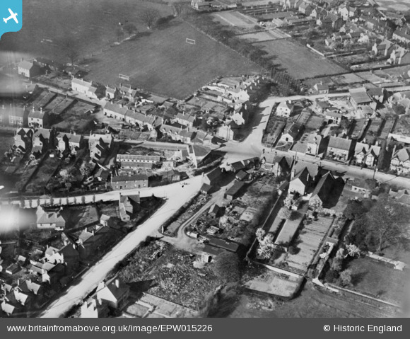
EPW015226 ENGLAND (1926). The junction of Old and New Penkridge Roads, Park Road and High Green, Cannock, 1926. This image has been produced from a copy-negative.
© Copyright OpenStreetMap contributors and licensed by the OpenStreetMap Foundation. 2026. Cartography is licensed as CC BY-SA.
Nearby Images (4)
EPW015226

EPW034057

EPW034059

EPW015227

Details
| Title | [EPW015226] The junction of Old and New Penkridge Roads, Park Road and High Green, Cannock, 1926. This image has been produced from a copy-negative. |
| Reference | EPW015226 |
| Date | 13-April-1926 |
| Link | |
| Place name | CANNOCK |
| Parish | |
| District | |
| Country | ENGLAND |
| Easting / Northing | 397768, 310283 |
| Longitude / Latitude | -2.0330257006311, 52.689884657353 |
| National Grid Reference | SJ978103 |
Pins

SteveB09 |
Friday 21st of April 2023 05:31:19 PM | |
|
SteveB09 |
Friday 21st of April 2023 05:30:11 PM | |
|
SteveB09 |
Friday 21st of April 2023 05:29:29 PM | |
|
SteveB09 |
Friday 21st of April 2023 05:28:06 PM | |
|
SteveB09 |
Friday 21st of April 2023 05:27:52 PM | |
|
SteveB09 |
Friday 21st of April 2023 05:27:32 PM | |
|
SteveB09 |
Friday 21st of April 2023 05:19:28 PM | |
|
D Dolphin |
Thursday 2nd of January 2020 12:17:43 PM | |
|
Mr.Raffles |
Monday 20th of April 2015 06:28:33 PM |