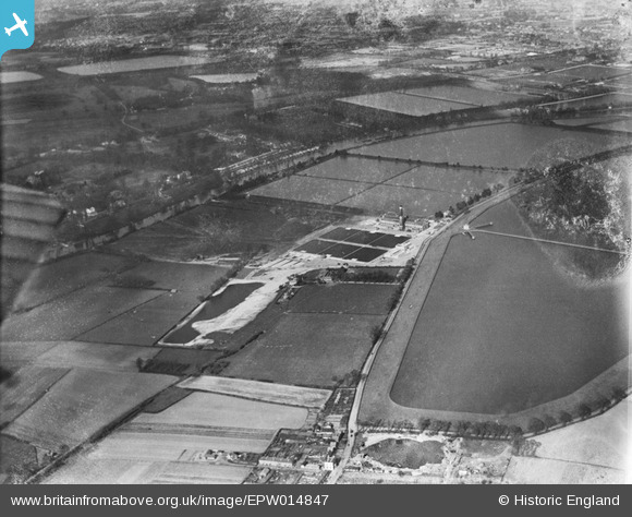
EPW014847 ENGLAND (1926). The Water Works and surrounding reservoirs, Walton-on-Thames, 1926
© Copyright OpenStreetMap contributors and licensed by the OpenStreetMap Foundation. 2026. Cartography is licensed as CC BY-SA.
Nearby Images (15)
Details
| Title | [EPW014847] The Water Works and surrounding reservoirs, Walton-on-Thames, 1926 |
| Reference | EPW014847 |
| Date | 30-March-1926 |
| Link | |
| Place name | WALTON-ON-THAMES |
| Parish | |
| District | |
| Country | ENGLAND |
| Easting / Northing | 511559, 168380 |
| Longitude / Latitude | -0.39601975051817, 51.402969369403 |
| National Grid Reference | TQ116684 |
Pins
Be the first to add a comment to this image!


![[EPW014847] The Water Works and surrounding reservoirs, Walton-on-Thames, 1926](http://britainfromabove.org.uk/sites/all/libraries/aerofilms-images/public/100x100/EPW/014/EPW014847.jpg)
![[EPW015604] The Metropolitan Water Board Water Works, West Molesey, 1926](http://britainfromabove.org.uk/sites/all/libraries/aerofilms-images/public/100x100/EPW/015/EPW015604.jpg)
![[EPW014844] The Water Works, Walton-on-Thames, 1926](http://britainfromabove.org.uk/sites/all/libraries/aerofilms-images/public/100x100/EPW/014/EPW014844.jpg)
![[EPW015608] The Metropolitan Water Board Water Works, West Molesey, 1926](http://britainfromabove.org.uk/sites/all/libraries/aerofilms-images/public/100x100/EPW/015/EPW015608.jpg)
![[EPW014845] The Water Works and surrounding reservoirs, Walton-on-Thames, 1926](http://britainfromabove.org.uk/sites/all/libraries/aerofilms-images/public/100x100/EPW/014/EPW014845.jpg)
![[EPW015607] The Metropolitan Water Board Water Works, West Molesey, 1926](http://britainfromabove.org.uk/sites/all/libraries/aerofilms-images/public/100x100/EPW/015/EPW015607.jpg)
![[EPW015605] The Metropolitan Water Board Water Works, West Molesey, 1926](http://britainfromabove.org.uk/sites/all/libraries/aerofilms-images/public/100x100/EPW/015/EPW015605.jpg)
![[EPW049602] The Walton Pumping Station and Treatment Works and environs, Walton-on-Thames, from the south-east, 1936](http://britainfromabove.org.uk/sites/all/libraries/aerofilms-images/public/100x100/EPW/049/EPW049602.jpg)
![[EPW015609] The Metropolitan Water Board Water Works, West Molesey, 1926](http://britainfromabove.org.uk/sites/all/libraries/aerofilms-images/public/100x100/EPW/015/EPW015609.jpg)
![[EPW014846] The Water Works and surrounding reservoirs, Walton-on-Thames, 1926](http://britainfromabove.org.uk/sites/all/libraries/aerofilms-images/public/100x100/EPW/014/EPW014846.jpg)
![[EPW015606] The Metropolitan Water Board Water Works, West Molesey, 1926](http://britainfromabove.org.uk/sites/all/libraries/aerofilms-images/public/100x100/EPW/015/EPW015606.jpg)
![[EPW015603] The Metropolitan Water Board Water Works, West Molesey, 1926](http://britainfromabove.org.uk/sites/all/libraries/aerofilms-images/public/100x100/EPW/015/EPW015603.jpg)
![[EPW015602] The Metropolitan Water Board Water Works, West Molesey, 1926](http://britainfromabove.org.uk/sites/all/libraries/aerofilms-images/public/100x100/EPW/015/EPW015602.jpg)
![[EPW014848] The Water Works and surrounding reservoirs, Walton-on-Thames, 1926](http://britainfromabove.org.uk/sites/all/libraries/aerofilms-images/public/100x100/EPW/014/EPW014848.jpg)
![[EPW049606] The River Thames at Swan's Rest Island and environs, Walton-on-Thames, 1936](http://britainfromabove.org.uk/sites/all/libraries/aerofilms-images/public/100x100/EPW/049/EPW049606.jpg)