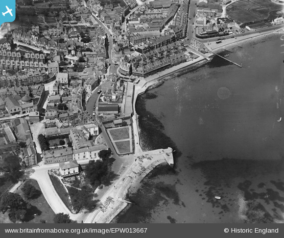
EPW013667 ENGLAND (1925). The Parade, Swanage, 1925
    © Copyright OpenStreetMap contributors and licensed by the OpenStreetMap Foundation. 2025. Cartography is licensed as CC BY-SA.
  
Nearby Images (5)
Details
| Title | [EPW013667] The Parade, Swanage, 1925 | 
| Reference | EPW013667 | 
| Date | July-1925 | 
| Link | |
| Place name | SWANAGE | 
| Parish | SWANAGE | 
| District | |
| Country | ENGLAND | 
| Easting / Northing | 403277, 78734 | 
| Longitude / Latitude | -1.9536838349286, 50.607726430843 | 
| National Grid Reference | SZ033787 | 
 
             
  ![[EPW013667] The Parade, Swanage, 1925](http://britainfromabove.org.uk/sites/all/libraries/aerofilms-images/public/100x100/EPW/013/EPW013667.jpg) 
  
                                          ![[EPW013669] The sea front and town centre, Swanage, 1925](http://britainfromabove.org.uk/sites/all/libraries/aerofilms-images/public/100x100/EPW/013/EPW013669.jpg) 
 ![[EPW013664] The town centre, Swanage, 1925](http://britainfromabove.org.uk/sites/all/libraries/aerofilms-images/public/100x100/EPW/013/EPW013664.jpg) 
 ![[EAW030873] The town, Swanage, 1950](http://britainfromabove.org.uk/sites/all/libraries/aerofilms-images/public/100x100/EAW/030/EAW030873.jpg) 
 ![[EPW013668] Beymer Road and surroundings, Swanage, 1925](http://britainfromabove.org.uk/sites/all/libraries/aerofilms-images/public/100x100/EPW/013/EPW013668.jpg) 
  High Street
 High Street 
 
 
