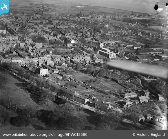
EPW012680 ENGLAND (1925). St Mary's Church and the town, Barton-upon-Humber, from the south-east, 1925
© Copyright OpenStreetMap contributors and licensed by the OpenStreetMap Foundation. 2026. Cartography is licensed as CC BY-SA.
Details
| Title | [EPW012680] St Mary's Church and the town, Barton-upon-Humber, from the south-east, 1925 |
| Reference | EPW012680 |
| Date | 6-May-1925 |
| Link | |
| Place name | BARTON-UPON-HUMBER |
| Parish | BARTON-UPON-HUMBER |
| District | |
| Country | ENGLAND |
| Easting / Northing | 503497, 421763 |
| Longitude / Latitude | -0.4328024793351, 53.68183331313 |
| National Grid Reference | TA035218 |
Pins

Bartonian |
Saturday 6th of December 2014 07:33:23 PM | |

Class31 |
Wednesday 19th of November 2014 09:47:25 AM | |

Class31 |
Wednesday 19th of November 2014 09:46:11 AM | |

aerialandy |
Sunday 29th of June 2014 05:04:29 PM |
User Comment Contributions
St. Mary's Church, Barton upon Humber, 29/08/2014 |

Class31 |
Wednesday 19th of November 2014 09:44:29 AM |
St. Mary's Church, Barton upon Humber, 29/08/2014 |

Class31 |
Wednesday 19th of November 2014 09:44:02 AM |
Field in foreground now site of several bungalows built in 1950s to early 1960's |

Bartonian |
Friday 19th of September 2014 01:18:05 PM |


![[EPW012680] St Mary's Church and the town, Barton-upon-Humber, from the south-east, 1925](http://britainfromabove.org.uk/sites/all/libraries/aerofilms-images/public/100x100/EPW/012/EPW012680.jpg)
![[EAW046162] The town, Barton-Upon-Humber, from the east, 1952](http://britainfromabove.org.uk/sites/all/libraries/aerofilms-images/public/100x100/EAW/046/EAW046162.jpg)
![[EAW046051] The Elswick Hopper Cycle Works off Castledykes South, Barton-Upon-Humber, 1952. This image was marked by Aerofilms Ltd for photo editing.](http://britainfromabove.org.uk/sites/all/libraries/aerofilms-images/public/100x100/EAW/046/EAW046051.jpg)