
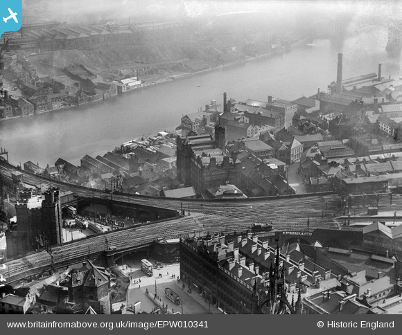
EPW010341 ENGLAND (1924). R. Robinson and Company Works (Turnball Warehouse) and environs, Newcastle upon Tyne, 1924
© Copyright OpenStreetMap contributors and licensed by the OpenStreetMap Foundation. 2026. Cartography is licensed as CC BY-SA.
Nearby Images (20)
EPW010341
 and environs, Newcastle upon Tyne, 1924")
EPW010342

EPW010344
, Newcastle upon Tyne, 1924")
EPW010392

EPW010345
, Newcastle upon Tyne, 1924")
EPW009980
, Newcastle upon Tyne, 1924")
EPW010395
 and the surrounding city, Newcastle upon Tyne, 1924. This image has been produced from a print.")
EPW010343
 and environs, Newcastle upon Tyne, 1924. This image has been produced from a print.")
EPW010411

EPW009979

EPW048800

EPW010393

EPW009976

EPW009975

EPW009978

EPW019825

EPW009977

EAW405203

EAW017459

EPW010391

Details
| Title | [EPW010341] R. Robinson and Company Works (Turnball Warehouse) and environs, Newcastle upon Tyne, 1924 |
| Reference | EPW010341 |
| Date | April-1924 |
| Link | |
| Place name | NEWCASTLE UPON TYNE |
| Parish | |
| District | |
| Country | ENGLAND |
| Easting / Northing | 424969, 563818 |
| Longitude / Latitude | -1.6099363210222, 54.968282133477 |
| National Grid Reference | NZ250638 |
Pins

John Wass |
Tuesday 15th of July 2014 08:23:39 PM | |
|
John Wass |
Tuesday 15th of July 2014 08:21:53 PM |