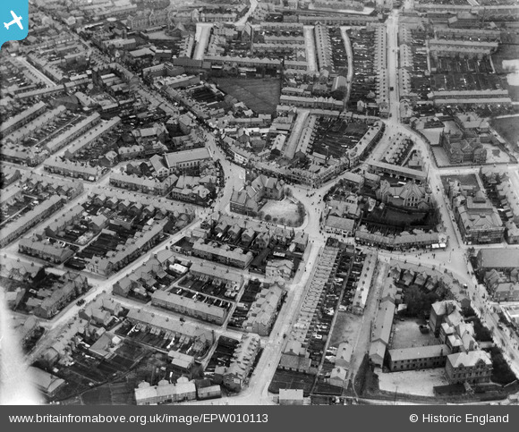
EPW010113 ENGLAND (1924). Regent's Circus and environs, Swindon, 1924
© Copyright OpenStreetMap contributors and licensed by the OpenStreetMap Foundation. 2026. Cartography is licensed as CC BY-SA.
Nearby Images (8)
Details
| Title | [EPW010113] Regent's Circus and environs, Swindon, 1924 |
| Reference | EPW010113 |
| Date | April-1924 |
| Link | |
| Place name | SWINDON |
| Parish | |
| District | |
| Country | ENGLAND |
| Easting / Northing | 415230, 184433 |
| Longitude / Latitude | -1.7802871792555, 51.558096843421 |
| National Grid Reference | SU152844 |
Pins

Keith |
Thursday 4th of April 2024 08:35:32 PM | |

Gary |
Tuesday 16th of January 2024 03:32:33 PM | |

davidendley |
Friday 17th of April 2020 08:51:48 AM | |

Class31 |
Saturday 26th of March 2016 08:49:42 AM | |

Elmlover3 |
Saturday 4th of January 2014 04:37:12 PM | |
We moved to Swindon at Easter 1958 and it was still standing then, looking rather gloomy and forlorn. |

gBr |
Friday 25th of September 2015 01:59:45 PM |

Elmlover3 |
Friday 3rd of January 2014 05:57:17 PM | |

Elmlover3 |
Friday 3rd of January 2014 05:55:20 PM | |

Elmlover3 |
Friday 3rd of January 2014 05:53:31 PM | |

Elmlover3 |
Friday 3rd of January 2014 05:52:04 PM | |

Elmlover3 |
Friday 3rd of January 2014 05:51:14 PM | |

Elmlover3 |
Friday 3rd of January 2014 05:50:25 PM |
User Comment Contributions
Clarence Street Infants and Junior Schools, Swindon, 07/05/2015 |

Class31 |
Monday 11th of May 2015 10:11:18 AM |


![[EPW010113] Regent's Circus and environs, Swindon, 1924](http://britainfromabove.org.uk/sites/all/libraries/aerofilms-images/public/100x100/EPW/010/EPW010113.jpg)
![[EPW010114] Regent Circus, Swindon, 1924. This image has been produced from a copy-negative.](http://britainfromabove.org.uk/sites/all/libraries/aerofilms-images/public/100x100/EPW/010/EPW010114.jpg)
![[EPW010115] Regent's Circus and environs, Swindon, 1924](http://britainfromabove.org.uk/sites/all/libraries/aerofilms-images/public/100x100/EPW/010/EPW010115.jpg)
![[EPW010111] Rolleston Street, Regent Circus and environs, Swindon, 1924. This image has been produced from a copy-negative.](http://britainfromabove.org.uk/sites/all/libraries/aerofilms-images/public/100x100/EPW/010/EPW010111.jpg)
![[EPW000937] View of New Town, Swindon, 1920](http://britainfromabove.org.uk/sites/all/libraries/aerofilms-images/public/100x100/EPW/000/EPW000937.jpg)
![[EAW006872] The town, Swindon, 1947](http://britainfromabove.org.uk/sites/all/libraries/aerofilms-images/public/100x100/EAW/006/EAW006872.jpg)
![[EPW059044] The area between Commercial Road and the railway station, Swindon, 1938](http://britainfromabove.org.uk/sites/all/libraries/aerofilms-images/public/100x100/EPW/059/EPW059044.jpg)
![[EPW010116] Regent's Circus and environs, Swindon, 1924](http://britainfromabove.org.uk/sites/all/libraries/aerofilms-images/public/100x100/EPW/010/EPW010116.jpg)