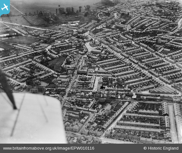
EPW010116 ENGLAND (1924). Regent's Circus and environs, Swindon, 1924
© Copyright OpenStreetMap contributors and licensed by the OpenStreetMap Foundation. 2026. Cartography is licensed as CC BY-SA.
Nearby Images (6)
Details
| Title | [EPW010116] Regent's Circus and environs, Swindon, 1924 |
| Reference | EPW010116 |
| Date | April-1924 |
| Link | |
| Place name | SWINDON |
| Parish | |
| District | |
| Country | ENGLAND |
| Easting / Northing | 415048, 184618 |
| Longitude / Latitude | -1.7829048281915, 51.559765314726 |
| National Grid Reference | SU150846 |
Pins

Gary |
Tuesday 16th of January 2024 03:42:23 PM | |

NottmJas |
Sunday 17th of September 2023 12:11:58 AM | |

NottmJas |
Sunday 17th of September 2023 12:11:21 AM | |

Class31 |
Monday 11th of May 2015 10:09:55 AM | |

Class31 |
Tuesday 14th of January 2014 11:18:09 AM | |

Class31 |
Tuesday 14th of January 2014 11:16:37 AM | |

Class31 |
Tuesday 14th of January 2014 11:15:56 AM |
User Comment Contributions
View looking south east |

Class31 |
Tuesday 14th of January 2014 11:17:19 AM |


![[EPW010116] Regent's Circus and environs, Swindon, 1924](http://britainfromabove.org.uk/sites/all/libraries/aerofilms-images/public/100x100/EPW/010/EPW010116.jpg)
![[EPW059044] The area between Commercial Road and the railway station, Swindon, 1938](http://britainfromabove.org.uk/sites/all/libraries/aerofilms-images/public/100x100/EPW/059/EPW059044.jpg)
![[EPW059046] The area between Princes Street and The Park, Swindon, 1938](http://britainfromabove.org.uk/sites/all/libraries/aerofilms-images/public/100x100/EPW/059/EPW059046.jpg)
![[EAW006872] The town, Swindon, 1947](http://britainfromabove.org.uk/sites/all/libraries/aerofilms-images/public/100x100/EAW/006/EAW006872.jpg)
![[EPW010114] Regent Circus, Swindon, 1924. This image has been produced from a copy-negative.](http://britainfromabove.org.uk/sites/all/libraries/aerofilms-images/public/100x100/EPW/010/EPW010114.jpg)
![[EPW010113] Regent's Circus and environs, Swindon, 1924](http://britainfromabove.org.uk/sites/all/libraries/aerofilms-images/public/100x100/EPW/010/EPW010113.jpg)