
EPW009346 ENGLAND (1923). Construction of the underground station, Burnt Oak, 1923

© Copyright OpenStreetMap contributors and licensed by the OpenStreetMap Foundation. 2026. Cartography is licensed as CC BY-SA.
Nearby Images (21)
EPW009346

EPW009682

EPW009344

EPW016519

EPW009345

EPW009347

EPW016517

EPW009363

EPW031549

EPW031548

EPW031583

EPW019190

EPW019336

EPW031550

EPW016518

EPW001350

EPW034858

EPW035548

EPW019191

EPW019338

EPW019337

Details
| Title | [EPW009346] Construction of the underground station, Burnt Oak, 1923 |
| Reference | EPW009346 |
| Date | 1923 |
| Link | |
| Place name | BURNT OAK |
| Parish | |
| District | |
| Country | ENGLAND |
| Easting / Northing | 520314, 190691 |
| Longitude / Latitude | -0.26258979204043, 51.601719356141 |
| National Grid Reference | TQ203907 |
Pins

The Laird |
Thursday 4th of January 2018 02:46:51 PM | |
|
The Laird |
Thursday 4th of January 2018 02:43:59 PM | |
|
colsouth111 |
Tuesday 10th of March 2015 06:53:07 PM | |
|
colsouth111 |
Wednesday 22nd of October 2014 03:16:30 PM | |
|
colsouth111 |
Wednesday 22nd of October 2014 03:15:34 PM | |
|
colsouth111 |
Monday 18th of August 2014 07:22:37 PM | |
|
colsouth111 |
Monday 18th of August 2014 07:19:43 PM | |

Maurice |
Thursday 16th of May 2013 07:00:21 AM | |
|
Maurice |
Thursday 16th of May 2013 06:58:25 AM | |
|
Maurice |
Thursday 16th of May 2013 06:57:33 AM |
User Comment Contributions
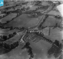
Another excellent early view of Burnt Oak with Watling Ave not yet laid and building of shops on High Road not yet commenced. |
colsouth111 |
Tuesday 21st of October 2014 01:46:07 PM |