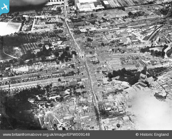
EPW009148 ENGLAND (1923). St Peter's Street and Westgate, Canterbury, 1923. This image has been produced from a print.
    © Copyright OpenStreetMap contributors and licensed by the OpenStreetMap Foundation. 2025. Cartography is licensed as CC BY-SA.
  
Nearby Images (5)
Details
| Title | [EPW009148] St Peter's Street and Westgate, Canterbury, 1923. This image has been produced from a print. | 
| Reference | EPW009148 | 
| Date | 1923 | 
| Link | |
| Place name | CANTERBURY | 
| Parish | |
| District | |
| Country | ENGLAND | 
| Easting / Northing | 614663, 158036 | 
| Longitude / Latitude | 1.0784101398098, 51.280445923377 | 
| National Grid Reference | TR147580 | 
Pins
User Comment Contributions
|   The Causeway Deans Mill Court from west |   Marian | Sunday 8th of May 2016 04:01:07 PM | 
 
             
  ![[EPW009148] St Peter's Street and Westgate, Canterbury, 1923. This image has been produced from a print.](http://britainfromabove.org.uk/sites/all/libraries/aerofilms-images/public/100x100/EPW/009/EPW009148.jpg) 
  
                                          ![[EPW000396] Canterbury, Kent, from the west, 1920](http://britainfromabove.org.uk/sites/all/libraries/aerofilms-images/public/100x100/EPW/000/EPW000396.jpg) 
 ![[EPW013267] West Gate and the city centre, Canterbury, 1925. This image has been produced from a copy-negative.](http://britainfromabove.org.uk/sites/all/libraries/aerofilms-images/public/100x100/EPW/013/EPW013267.jpg) 
 ![[EAW004803] The city centre, Canterbury, from the north-east, 1947](http://britainfromabove.org.uk/sites/all/libraries/aerofilms-images/public/100x100/EAW/004/EAW004803.jpg) 
 ![[EAW004804] The city centre, Canterbury, from the west, 1947](http://britainfromabove.org.uk/sites/all/libraries/aerofilms-images/public/100x100/EAW/004/EAW004804.jpg) 
  Forty Acres Road
 Forty Acres Road