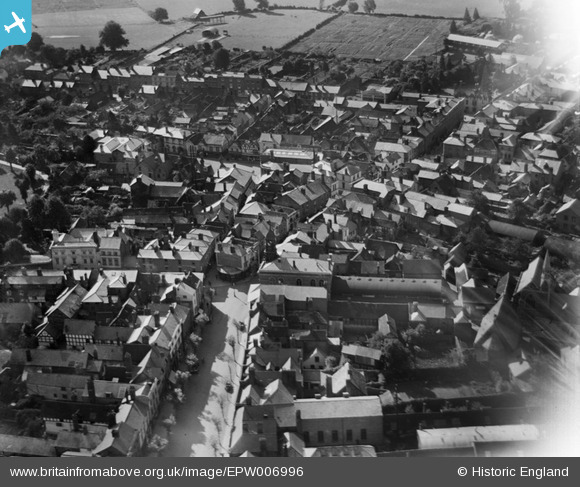
EPW006996 ENGLAND (1921). Butter Cross, Leominster, 1921
© Copyright OpenStreetMap contributors and licensed by the OpenStreetMap Foundation. 2025. Cartography is licensed as CC BY-SA.
Nearby Images (6)
Details
| Title | [EPW006996] Butter Cross, Leominster, 1921 |
| Reference | EPW006996 |
| Date | 31-August-1921 |
| Link | |
| Place name | LEOMINSTER |
| Parish | LEOMINSTER |
| District | |
| Country | ENGLAND |
| Easting / Northing | 349640, 259081 |
| Longitude / Latitude | -2.7373851813447, 52.227226865349 |
| National Grid Reference | SO496591 |
Pins
User Comment Contributions
View looking south. |

Class31 |
Monday 13th of August 2012 04:03:05 PM |


![[EPW006996] Butter Cross, Leominster, 1921](http://britainfromabove.org.uk/sites/all/libraries/aerofilms-images/public/100x100/EPW/006/EPW006996.jpg)
![[EPW006998] The High Street and environs, Leominster, 1921](http://britainfromabove.org.uk/sites/all/libraries/aerofilms-images/public/100x100/EPW/006/EPW006998.jpg)
![[EPW005065] General view of the town centre, Leominster, 1920](http://britainfromabove.org.uk/sites/all/libraries/aerofilms-images/public/100x100/EPW/005/EPW005065.jpg)
![[EPW006997] Church Street and the Priory Church of St Peter and St Paul, Leominster, 1921](http://britainfromabove.org.uk/sites/all/libraries/aerofilms-images/public/100x100/EPW/006/EPW006997.jpg)
![[EPW005063] General view of the town centre, Leominster, 1920](http://britainfromabove.org.uk/sites/all/libraries/aerofilms-images/public/100x100/EPW/005/EPW005063.jpg)
![[EPW005062] The Priory Church of St Peter and St Paul, Leominster, 1920](http://britainfromabove.org.uk/sites/all/libraries/aerofilms-images/public/100x100/EPW/005/EPW005062.jpg)