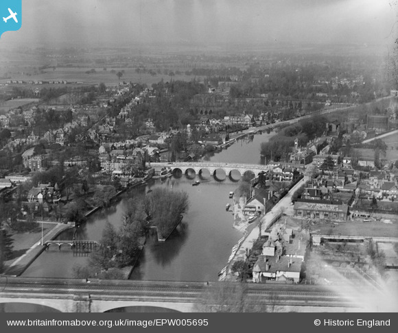
EPW005695 ENGLAND (1921). View of the town and Maidenhead Bridge, Maidenhead, from the south-east, 1921
    © Copyright OpenStreetMap contributors and licensed by the OpenStreetMap Foundation. 2025. Cartography is licensed as CC BY-SA.
  
Nearby Images (16)
Details
| Title | [EPW005695] View of the town and Maidenhead Bridge, Maidenhead, from the south-east, 1921 | 
| Reference | EPW005695 | 
| Date | March-1921 | 
| Link | |
| Place name | MAIDENHEAD | 
| Parish | |
| District | |
| Country | ENGLAND | 
| Easting / Northing | 490176, 181169 | 
| Longitude / Latitude | -0.70010390564108, 51.521749499081 | 
| National Grid Reference | SU902812 | 
Pins
|  Maidenhead gasworks |   misterjohn | Sunday 1st of January 2023 04:27:06 PM | 
|  I lodged there in the 60`s |   fern | Sunday 8th of March 2020 06:13:04 PM | 
|  Garage |   fern | Sunday 8th of March 2020 06:11:08 PM | 
|  Thames Hotel. |   fern | Sunday 8th of March 2020 06:10:19 PM | 
|  Old Maidenhead Rowing Club boathouse. Now on other (Bucks) bank |   GrahamT | Tuesday 18th of December 2012 09:22:21 PM | 
|  Guards Club Island also known as Bucks Ait | Class31 | Tuesday 30th of October 2012 04:34:58 PM | 
|  Sign reads Riviera Hotel | Class31 | Tuesday 30th of October 2012 04:34:06 PM | 
|  Maidenhead Bridge conveys the Bath Road A4 over the River Thames. It is Grade 1 listed. | Class31 | Tuesday 30th of October 2012 04:33:31 PM | 
 
             
  ![[EPW005695] View of the town and Maidenhead Bridge, Maidenhead, from the south-east, 1921](http://britainfromabove.org.uk/sites/all/libraries/aerofilms-images/public/100x100/EPW/005/EPW005695.jpg) 
  
                                          ![[EPW022619] Maidenhead Bridge and surroundings, Maidenhead, 1928](http://britainfromabove.org.uk/sites/all/libraries/aerofilms-images/public/100x100/EPW/022/EPW022619.jpg) 
 ![[EPW056581] Maidenhead Bridge, the Fish Weir and the Railway Viaduct, Maidenhead, 1938](http://britainfromabove.org.uk/sites/all/libraries/aerofilms-images/public/100x100/EPW/056/EPW056581.jpg) 
 ![[EPW022710] Maidenhead Bridge and Maidenhead Viaduct, Maidenhead, 1928](http://britainfromabove.org.uk/sites/all/libraries/aerofilms-images/public/100x100/EPW/022/EPW022710.jpg) 
 ![[EAW021598] Maidenhead Bridge and the River Thameas, Maidenhead, from the south-west, 1949](http://britainfromabove.org.uk/sites/all/libraries/aerofilms-images/public/100x100/EAW/021/EAW021598.jpg) 
 ![[EPW022721] Maidenhead Bridge, Maidenhead, 1928](http://britainfromabove.org.uk/sites/all/libraries/aerofilms-images/public/100x100/EPW/022/EPW022721.jpg) 
 ![[EAW013948] Maidenhead Bridge, Ray Park Avenue and environs, Maidenhead, from the south, 1948. This image has been produced from a print.](http://britainfromabove.org.uk/sites/all/libraries/aerofilms-images/public/100x100/EAW/013/EAW013948.jpg) 
 ![[EAW003666] Flooding around Maidenhead Bridge and Bridge Road, Maidenhead, from the east, 1947](http://britainfromabove.org.uk/sites/all/libraries/aerofilms-images/public/100x100/EAW/003/EAW003666.jpg) 
 ![[EAW013949] Maidenhead Bridge and the River Thames, Maidenhead, from the south, 1948. This image has been produced from a damaged negative.](http://britainfromabove.org.uk/sites/all/libraries/aerofilms-images/public/100x100/EAW/013/EAW013949.jpg) 
 ![[EAW021597] Maidenhead Bridge and the surrounding area, Maidenhead, 1949. This image has been produced from a print.](http://britainfromabove.org.uk/sites/all/libraries/aerofilms-images/public/100x100/EAW/021/EAW021597.jpg) 
 ![[EPW056582] Maidenhead Bridge and the town, Maidenhead, from the south, 1938](http://britainfromabove.org.uk/sites/all/libraries/aerofilms-images/public/100x100/EPW/056/EPW056582.jpg) 
 ![[EAW029470] Maidenhead Bridge, the railway viaduct and River Thames, Taplow, 1950](http://britainfromabove.org.uk/sites/all/libraries/aerofilms-images/public/100x100/EAW/029/EAW029470.jpg) 
 ![[EAW003664] Extensive flooding along the River Thames, Maidenhead, 1947](http://britainfromabove.org.uk/sites/all/libraries/aerofilms-images/public/100x100/EAW/003/EAW003664.jpg) 
 ![[EAW026482] Maidenhead Viaduct and the town, Maidenhead, from the south, 1949](http://britainfromabove.org.uk/sites/all/libraries/aerofilms-images/public/100x100/EAW/026/EAW026482.jpg) 
 ![[EAW021599] Maidenhead Bridge and the surrounding area, Maidenhead, 1949. This image has been produced from a print.](http://britainfromabove.org.uk/sites/all/libraries/aerofilms-images/public/100x100/EAW/021/EAW021599.jpg) 
 ![[EAW021596] Maidenhead Bridge and the surrounding area, Maidenhead, 1949. This image has been produced from a print.](http://britainfromabove.org.uk/sites/all/libraries/aerofilms-images/public/100x100/EAW/021/EAW021596.jpg)