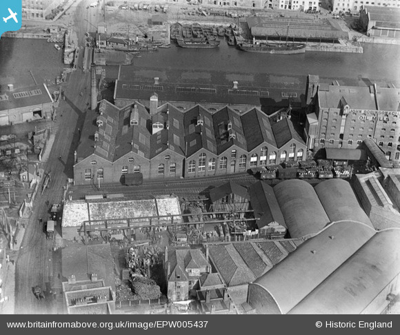
EPW005437 ENGLAND (1921). Bathurst Wharf, Bristol, 1921
    © Copyright OpenStreetMap contributors and licensed by the OpenStreetMap Foundation. 2025. Cartography is licensed as CC BY-SA.
  
Nearby Images (17)
Details
| Title | [EPW005437] Bathurst Wharf, Bristol, 1921 | 
| Reference | EPW005437 | 
| Date | 20-March-1921 | 
| Link | |
| Place name | BRISTOL | 
| Parish | |
| District | |
| Country | ENGLAND | 
| Easting / Northing | 358674, 172249 | 
| Longitude / Latitude | -2.5947391434478, 51.447229480895 | 
| National Grid Reference | ST587722 | 
 
             
  ![[EPW005437] Bathurst Wharf, Bristol, 1921](http://britainfromabove.org.uk/sites/all/libraries/aerofilms-images/public/100x100/EPW/005/EPW005437.jpg) 
  
                                          ![[EPW005436] Bathurst Wharf, Bristol, 1921](http://britainfromabove.org.uk/sites/all/libraries/aerofilms-images/public/100x100/EPW/005/EPW005436.jpg) 
 ![[EPW005438] Bathurst Wharf, Bristol, 1921](http://britainfromabove.org.uk/sites/all/libraries/aerofilms-images/public/100x100/EPW/005/EPW005438.jpg) 
 ![[EPW005434] Bathurst Wharf, Bristol, 1921](http://britainfromabove.org.uk/sites/all/libraries/aerofilms-images/public/100x100/EPW/005/EPW005434.jpg) 
 ![[EPW005435] Bathurst Wharf, Bristol, 1921](http://britainfromabove.org.uk/sites/all/libraries/aerofilms-images/public/100x100/EPW/005/EPW005435.jpg) 
 ![[EAW586137] Bathurst Wharf, Bristol, 1990](http://britainfromabove.org.uk/sites/all/libraries/aerofilms-images/public/100x100/EAW/586/EAW586137.jpg) 
 ![[EPW005433] Prince's Wharf Granaries and the Bristol Harbour Branch Goods Yard, Bristol, 1921](http://britainfromabove.org.uk/sites/all/libraries/aerofilms-images/public/100x100/EPW/005/EPW005433.jpg) 
 ![[EPW044769] Bathurst Parade, the Bathurst Basin, Holms Sand and Gravel Co Ltd and environs, Bristol, 1934](http://britainfromabove.org.uk/sites/all/libraries/aerofilms-images/public/100x100/EPW/044/EPW044769.jpg) 
 ![[EAW209373] Queen Square and the Floating Harbour, Bristol, 1971](http://britainfromabove.org.uk/sites/all/libraries/aerofilms-images/public/100x100/EAW/209/EAW209373.jpg) 
 ![[EPW044771] The River Avon, Bathurst Basin, Queen Square and environs, Bristol, 1934](http://britainfromabove.org.uk/sites/all/libraries/aerofilms-images/public/100x100/EPW/044/EPW044771.jpg) 
 ![[EPW044768] The Bathurst Basin, Holms Sand and Gravel Co Ltd and environs, Bristol, 1934](http://britainfromabove.org.uk/sites/all/libraries/aerofilms-images/public/100x100/EPW/044/EPW044768.jpg) 
 ![[EPW044770] Bathurst Parade, the Bathurst Basin, Holms Sand and Gravel Co Ltd and environs, Bristol, 1934](http://britainfromabove.org.uk/sites/all/libraries/aerofilms-images/public/100x100/EPW/044/EPW044770.jpg) 
 ![[EPW044772] Bathurst Parade, the Bathurst Basin, Holms Sand and Gravel Co Ltd and environs, Bristol, 1934](http://britainfromabove.org.uk/sites/all/libraries/aerofilms-images/public/100x100/EPW/044/EPW044772.jpg) 
 ![[EPW044774] The Bathurst Basin, Holms Sand and Gravel Co Ltd and environs, Bristol, 1934](http://britainfromabove.org.uk/sites/all/libraries/aerofilms-images/public/100x100/EPW/044/EPW044774.jpg) 
 ![[EPW044773] The Bathurst Basin, Queen Square and environs, Bristol, from the south, 1934](http://britainfromabove.org.uk/sites/all/libraries/aerofilms-images/public/100x100/EPW/044/EPW044773.jpg) 
 ![[EPW033506] Canon's Marsh and environs, Bristol, 1930](http://britainfromabove.org.uk/sites/all/libraries/aerofilms-images/public/100x100/EPW/033/EPW033506.jpg) 
 ![[EPW041479] Canon's Marsh and the city centre, Bristol, from the south, 1933](http://britainfromabove.org.uk/sites/all/libraries/aerofilms-images/public/100x100/EPW/041/EPW041479.jpg) 
  Wapping Road looking north 20/2/2014
 Wapping Road looking north 20/2/2014