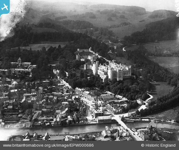
EPW000686 ENGLAND (1920). Arundel Castle, Arundel, from the south, 1920
© Copyright OpenStreetMap contributors and licensed by the OpenStreetMap Foundation. 2025. Cartography is licensed as CC BY-SA.
Nearby Images (15)
Details
| Title | [EPW000686] Arundel Castle, Arundel, from the south, 1920 |
| Reference | EPW000686 |
| Date | April-1920 |
| Link | |
| Place name | ARUNDEL |
| Parish | ARUNDEL |
| District | |
| Country | ENGLAND |
| Easting / Northing | 501839, 107291 |
| Longitude / Latitude | -0.55299006736706, 50.855597768984 |
| National Grid Reference | TQ018073 |
Pins

gBr |
Monday 19th of September 2016 09:55:31 PM | |

ceb |
Sunday 18th of September 2016 08:51:50 AM | |

ceb |
Sunday 18th of September 2016 08:49:46 AM | |

ceb |
Sunday 18th of September 2016 08:48:33 AM | |

blackcat |
Saturday 13th of December 2014 05:49:48 PM | |

blackcat |
Saturday 13th of December 2014 05:42:54 PM | |

Alan McFaden |
Sunday 18th of May 2014 04:40:15 PM | |

Alan McFaden |
Monday 22nd of July 2013 12:01:49 PM | |

Alan McFaden |
Monday 22nd of July 2013 12:00:37 PM | |

Alan McFaden |
Monday 22nd of July 2013 11:54:10 AM | |

Alan McFaden |
Monday 22nd of July 2013 11:52:27 AM | |

Alan McFaden |
Monday 22nd of July 2013 11:50:06 AM | |

Alan McFaden |
Monday 22nd of July 2013 11:48:55 AM | |

Alan McFaden |
Monday 22nd of July 2013 11:47:42 AM | |

Alan McFaden |
Monday 22nd of July 2013 11:46:28 AM |


![[EPW000686] Arundel Castle, Arundel, from the south, 1920](http://britainfromabove.org.uk/sites/all/libraries/aerofilms-images/public/100x100/EPW/000/EPW000686.jpg)
![[EPW018264] Arundel Castle, Arundel, 1927. This image has been produced from a copy-negative.](http://britainfromabove.org.uk/sites/all/libraries/aerofilms-images/public/100x100/EPW/018/EPW018264.jpg)
![[EPW000726] The castle, Arundel, 1920. This image has been produced from a copy negative.](http://britainfromabove.org.uk/sites/all/libraries/aerofilms-images/public/100x100/EPW/000/EPW000726.jpg)
![[EAW021571] Arundel Castle, Arundel, 1949. This image has been produced from a print.](http://britainfromabove.org.uk/sites/all/libraries/aerofilms-images/public/100x100/EAW/021/EAW021571.jpg)
![[EAW050661] Arundel Castle, Arundel, 1953](http://britainfromabove.org.uk/sites/all/libraries/aerofilms-images/public/100x100/EAW/050/EAW050661.jpg)
![[EAW021569] Arundel Castle Keep and St Nicholas's Church, Arundel, 1949. This image has been produced from a print.](http://britainfromabove.org.uk/sites/all/libraries/aerofilms-images/public/100x100/EAW/021/EAW021569.jpg)
![[EPW000685] Arundel Castle and the Cathedral of Our Lady, Arundel, 1920](http://britainfromabove.org.uk/sites/all/libraries/aerofilms-images/public/100x100/EPW/000/EPW000685.jpg)
![[EAW050663] Arundel Castle, Arundel, 1953](http://britainfromabove.org.uk/sites/all/libraries/aerofilms-images/public/100x100/EAW/050/EAW050663.jpg)
![[EAW050662] Arundel Castle and the town, Arundel, 1953](http://britainfromabove.org.uk/sites/all/libraries/aerofilms-images/public/100x100/EAW/050/EAW050662.jpg)
![[EAW021570] Arundel Castle Keep, Arundel, 1949. This image has been produced from a print.](http://britainfromabove.org.uk/sites/all/libraries/aerofilms-images/public/100x100/EAW/021/EAW021570.jpg)
![[EAW050664] Arundel Castle, Arundel, 1953](http://britainfromabove.org.uk/sites/all/libraries/aerofilms-images/public/100x100/EAW/050/EAW050664.jpg)
![[EAW021573] Arundel Castle, Arundel, from the south, 1949. This image has been produced from a print.](http://britainfromabove.org.uk/sites/all/libraries/aerofilms-images/public/100x100/EAW/021/EAW021573.jpg)
![[EPW000684] Arundel Castle, Arundel, from the north, 1920](http://britainfromabove.org.uk/sites/all/libraries/aerofilms-images/public/100x100/EPW/000/EPW000684.jpg)
![[EAW021574] Arundel Castle overlooking the town, Arundel, from the south-east, 1949. This image has been produced from a print.](http://britainfromabove.org.uk/sites/all/libraries/aerofilms-images/public/100x100/EAW/021/EAW021574.jpg)
![[EAW021576] Arundel Castle, the Cathedral Church of Our Lady and St Philip and environs, Arundel, from the south-west, 1949. This image has been produced from a print.](http://britainfromabove.org.uk/sites/all/libraries/aerofilms-images/public/100x100/EAW/021/EAW021576.jpg)


